

EU Water Emission Load Records — EEA WISE
Pricing
from $33.50 / 1,000 water emission load records
EU Water Emission Load Records — EEA WISE
Keyless pay-per-record EEA WISE Waterbase emissions to water — river basin, pollutant, source category, emissions value and unit in source units, method and status flags, verbatim. No person data. Gold $0.0335/record.
Pricing
from $33.50 / 1,000 water emission load records
Rating
0.0
(0)
Developer
NexGen Signal
Maintained by CommunityActor stats
0
Bookmarked
2
Total users
1
Monthly active users
15 hours ago
Last modified
Categories
Share
Keyless. Pay per record. Pollutant emissions to Europe's waters — by river basin, source category, and period, verbatim.
This actor turns the European Environment Agency (EEA) WISE State of Environment (Waterbase) emissions dataset into clean, per-record data — the pollutant emissions to water reported for Europe's river basins. Each run reads the EEA's keyless DiscoData SQL service and delivers one row per emission-load record, structured for water-pollution and catchment-load analysis, reusable with acknowledgement of the EEA, with no personal data of any kind.
What this is, in one paragraph
The EEA compiles national reporting of pollutant emissions to water into the WISE State of Environment (Waterbase) emissions dataset. This actor reads that emissions table and delivers one record per river basin / pollutant / source category / period: the country and spatial unit (river basin district), the reference period, the pollutant (determinand code and label), the emissions SOURCE CATEGORY, an EPRTR-facilities flag, and the emissions VALUE and UNIT in the source units verbatim, plus the emissions METHOD and observation-STATUS flags. It is the water-emissions layer of Europe's catchment pollution picture.
Who buys this and for what job
- Water-pollution analysts quantifying emissions to water by basin, pollutant, and source
- Catchment-load modelling teams feeding official emissions into pollution models
- Researchers comparing point vs diffuse emission sources to water across basins
- Data engineers who want the WISE water emissions table as clean rows from a keyless source.
EEA licence — reuse with acknowledgement
One licence rider travels on every record. EEA data may be reused, including commercially, provided the source is acknowledged: "Source: European Environment Agency (EEA)." Where third-party content is marked, it keeps its own terms. These are reported values as filed — not a compliance verdict.
River-basin grain — no person data
The unit of every record is a pollutant emission load for a basin, source, and period — a load figure, never a person. There is no contact, operator, or responsible-person field in the source, and none is selected or emitted; a person-key guard runs on every record as a backstop. Free-text remark fields are excluded at field selection.
Sample output
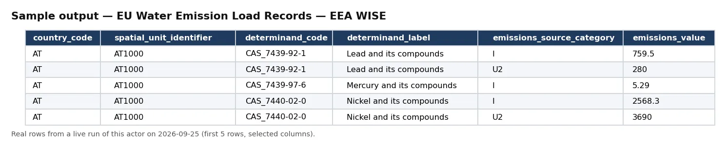
Real rows from a live run of this actor (first 5 rows, selected columns).
One full record from the same run, exactly as delivered:
Pricing
| Event | Free plan | Bronze | Silver | Gold / Platinum / Diamond |
|---|---|---|---|---|
water_emission_load_record | $0.05 | $0.045 | $0.04 | $0.0335 |
Delivered before charged. Blocked runs and empty results cost nothing.
Input
| Field | Type | Default | Description |
|---|---|---|---|
countryCode | string | — | Optional 2-letter country code (e.g. DE, FR). |
year | integer | — | Optional reference period to filter. |
maxRecords | integer | 500 | Ceiling on records delivered and billed. |
Output
One JSON object per emission-load record. Real example (values as reported):
An unbilled RUN_RECEIPT records the robots check, the filters, rows seen and delivered, and whether charged equals delivered.
Field reference
Each record is one emission load. Identity: record_id, country_code, spatial_unit_identifier, spatial_unit_identifier_scheme, and reference_period. Pollutant and source: determinand_code, determinand_label, emissions_source_category, and eprtr_facilities. Measurement: emissions_value, emissions_uom, emissions_method, and observation_status. Provenance travels on every record: source, source_url, licence, attribution, disclaimer, and observed_at.
How a run works
A run first re-reads the source host's robots posture from your runtime — the EEA DiscoData host — and stops at the door if that ever changes. It pages the WISE water emissions table (filtered to your optional countryCode and optional year), and flattens each row to one record — carrying every value verbatim, never anything person-shaped — delivered before it is charged, so a blocked or empty run costs you nothing. The actor stops at your maxRecords ceiling and records charge_equals_delivered in the receipt.
Coverage and scope
The table holds on the order of 171,771 rows. Because each record carries the determinand_label, emissions_source_category, and reference_period, segmenting is straightforward. Pull one slice, or the whole table to seed a warehouse.
Working with the data
The emission loads are a pollution ledger, and the fields make them additive. Because every record pairs a determinand_label with an emissions_value and emissions_uom and the emissions_source_category, an analyst can compare pollutant loads by source across basins without unit-guessing, and the emissions_method and observation_status flags travel so estimated or provisional figures can be handled explicitly. The reference_period frames each load in time.
Identifiers and joins
Every record carries the spatial_unit_identifier (river basin district), keying each emission load to the fleet's other WISE cells for that basin — the input-total inventory, the failing pollutants, and the river-basin-specific standards — on a shared identifier rather than a fuzzy name match.
Point, diffuse, and the EPRTR link
The emissions_source_category distinguishes the origin of a load — point sources, diffuse sources, and their sub-types — which is the first cut any catchment analysis needs, and the eprtr_facilities flag marks loads associated with the large industrial facilities reported under the E-PRTR. Together they let an analyst separate the industrial point-source contribution from diffuse agricultural and urban runoff for a given pollutant in a basin. The emissions_method (measured, calculated, estimated) and observation_status travel on every record so provisional or modelled loads are never silently mixed with measured ones.
Cost guidance
One water_emission_load_record per delivered row: cost = rows delivered × your plan's per-record price. Scope with countryCode and year to keep runs bounded. 1,000 rows is $50 (Free) / $33.50 (Gold).
Building a basin load series
Because every record carries the spatial_unit_identifier, determinand_code, emissions_source_category, and reference_period, a single filtered pull reconstructs a basin's emission trajectory for a pollutant and source over time, and the shared river-basin identifier means those loads line up directly with the input-inventory totals and failing pollutants reported for the same basin — turning three separate WISE cells into one connected picture of what enters a basin and what fails there.
Honest limitations
- As reported. Values, flags, and thresholds are as filed; this actor reformats, it does not audit or recompute.
- A label, not a verdict. These are reported statistics/regimes/volumes/loads, not an independent compliance assessment.
- Acknowledge the EEA. The acknowledgement travels on every record.
- No person data of any kind.
Differentiation
It is distinct from eu-basin-pollutant-input-total-records — that cell carries the WFD programme-of-measures INPUT INVENTORY totals (point-and-diffuse inputs with methodology), while this cell carries the State-of-Environment EMISSIONS to water by source category from Waterbase; a different dataset and grain. Its specific job is the WISE emissions to water.
The NexGen Signal family
Part of the NexGen Signal family of pay-per-record data products:
- EU Basin Pollutant Input Total Records — EEA WISE
- EU Waterbody Pesticide Exceedance Records — EEA WISE
- EU Surface Water Failing Pollutant Records — EEA WISE
- EU Nitrate Monitoring Records — EEA
- EU Waterbody Quality Records — EEA
Source: European Environment Agency (EEA), WISE State of Environment (Waterbase) (discodata.eea.europa.eu). EEA data may be reused, including commercially, provided the source is acknowledged: "Source: European Environment Agency (EEA)"; marked third-party content keeps its own terms. River-basin / pollutant / source / period grain; free-text remarks excluded, no contact/operator/responsible-person field selected or emitted. No natural-person data of any kind. Values as filed, not a compliance verdict.


