

NOAA GHCN Station Reference — Global Directory
Pricing
from $33.50 / 1,000 ghcn station records
NOAA GHCN Station Reference — Global Directory
NOAA GHCN-Daily station directory (ghcnd-stations.txt) as clean, per-record station reference - ID, coordinates, elevation, state and GSN/HCN/CRN/WMO flags for ~132,500 weather stations. Public-domain, $0.05 per record.
Pricing
from $33.50 / 1,000 ghcn station records
Rating
0.0
(0)
Developer
NexGen Signal
Maintained by CommunityActor stats
0
Bookmarked
2
Total users
1
Monthly active users
13 hours ago
Last modified
Categories
Share
Turn NOAA's GHCN-Daily station directory into clean, per-record station reference data - one row per weather station with its ID, coordinates, elevation and network flags, ready to normalize and geolocate observation networks worldwide.
Each line of NOAA's published fixed-width station file becomes one clean, flat record with
coordinates and elevation coerced to real numbers, a stable record_id (the station ID), and provenance
stamped on every row: source, source file, the public-domain notice, attribution, a UTC retrieval
timestamp and an interpretation caveat.
What one record represents
The source is NOAA NCEI's GHCN-Daily station directory — the file ghcnd-stations.txt, the master
reference list of the weather stations in the Global Historical Climatology Network. Each record is
one station: its GHCN identification code, latitude, longitude, elevation, U.S./Canada state (when
applicable), station name, the GSN and HCN/CRN network flags, and its WMO id when one is assigned.
The Actor parses the file by the exact column positions NOAA documents in the GHCN-Daily readme (section IV, "FORMAT OF ghcnd-stations.txt"), quoted here verbatim:
The first two characters of the station ID are the FIPS country code and the third is a network code, so the ID itself locates a station geographically and by numbering system.
Coverage and volume
The live directory holds 132,501 stations across the Global Historical Climatology Network - every country, from single-gauge sites to major airport stations - that is the record capacity of a full pull.
Live count: 132,501 station rows - matches the Wave-3 index figure exactly.
This is a directory (reference) product: one record per station, delivered in file order. Set Maximum records to sample or to pull the whole directory.
Licence and attribution
NOAA NCEI GHCN-Daily is a U.S. Government work in the public domain — free to use and redistribute with attribution. The full notice travels on every record:
NOAA NCEI GHCN-Daily. U.S. Government work, public domain (NWS/NCEI data-use); free to use and redistribute with attribution. Reproduced verbatim from the published fixed-width station file.
The required attribution — NOAA National Centers for Environmental Information (NCEI), GHCN-Daily — is present on every record.
Interpretation caveat
A station directory (reference), not observations. Elevation of -999.9 in the source denotes missing; state is present only for U.S./Canada stations; GSN and HCN/CRN flags are present only for stations in those networks. Station names are place names, never persons.
Values are reproduced verbatim from the published file: the Actor never rescales or re-derives a number.
Person-data policy
The GHCN station spec contains no observer or contact field — every column is a station identifier, coordinate, elevation, state, station name, network flag or WMO id. Station names are place names, never persons, and a per-record assertion enforces a person-field allow-list at write time.
Data quality and freshness
Latitude, longitude and elevation are coerced to real numbers; a source elevation of -999.9 denotes
missing and is reproduced verbatim so you can filter it explicitly. State, GSN, HCN/CRN and WMO fields
are present only where the network assigns them, and arrive as null otherwise. Every run re-reads the
live file and re-stamps observed_at, so scheduling the Actor keeps a downstream station table current
as NOAA adds or revises stations.
Provenance and compliance
Every run reads the exact host's robots.txt at runtime and refuses to proceed if the crawl policy
disallows the station-file path; the gate result (URL, status, byte length, SHA-256 of the policy) is
written to the run's RUN_RECEIPT. The Actor identifies itself with a transparent, non-impersonating
User-Agent and never bypasses a block or fetches through a mirror.
Inputs
- Maximum records (
maxRecords) — hard cap on station records delivered and billed. The full directory is about 132,500 stations.
Output
Records land in the Actor's default dataset and export as JSON, CSV, Excel or via the Apify API. A tabular overview view surfaces station id, name, state, coordinates, elevation and the network flags.
Fields in detail
The record leads with record_id (the station ID) and station_id, then latitude, longitude and
elevation as numbers, state, station_name, the gsn_flag and hcn_crn_flag network markers, and
wmo_id. The provenance block — source, source_dataset, licence, attribution, caveat,
observed_at — closes every record, so a single row is self-describing and audit-ready. Because delivery
is in file order and keyed on the stable station ID, the dataset is safe to diff, deduplicate or upsert
into a warehouse, and a station keeps the same record_id across runs.
Station ID structure
The GHCN station ID is itself a compact locator. Its first two characters are the FIPS country code (so
US, CA, AS, FR and so on group stations by country), the third character is a network code that
identifies the numbering system the station belongs to (for example 0 for an unspecified up-to-eight-
character id, 1 for a CoCoRaHS-based id, W for a WBAN-based id), and the remaining eight characters
carry the actual station number. That means you can filter or bucket the whole directory by country and
network directly off the station_id string, before any join, and the wmo_id gives you a second key
to line stations up against WMO-based feeds. The state field is populated only for stations in the
United States and Canada; elsewhere it is null, which is itself informative when you are partitioning a
global network by region.
Scaling and limits
Set Maximum records low to sample the leading stations cheaply, or to about 132,500 to pull the whole
directory in one run. The Actor reads the published file once and delivers incrementally, so memory stays
flat regardless of how many stations you request, and you are billed only for what is delivered. Because
the directory changes slowly, a scheduled weekly or monthly run is usually enough to keep a downstream
station table current; each run re-stamps observed_at so you always know how old your snapshot is.
Sibling Actors
This Actor is the station directory that observation feeds reference. It complements the fleet's observation cells - storm-event-records (NOAA storm events) and air-quality-monitor-records (EPA monitor readings): use this directory to describe and geolocate a station, and those cells for the measurements. Directory versus observations - distinct jobs. This Actor also shares its engineering — the runtime robots gate, push-then-charge
billing and verbatim-value discipline — with the fleet's other public-data records Actors.
Sample output
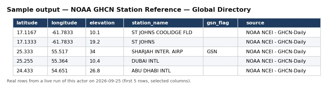
Real rows from a live run of this actor (first 5 rows, selected columns).
One full record from the same run, exactly as delivered:
Pricing
This Actor uses Apify's pay-per-event model: a flat $0.05 per record actually delivered to the dataset, and nothing else — no monthly rental, no per-run base fee, no compute charge. Deliver 40 records and you pay $2.00; deliver 10,000 and you pay $500.00. Billing is wired after delivery — each record is pushed first and only then does the per-record event fire — so a mid-run failure can only ever under-charge you, never over-charge. Use Maximum records to cap spend precisely.
Typical uses
Normalize and geolocate observation networks; join station coordinates and elevation onto weather or climate observations; filter to GSN or HCN/CRN reference networks; build a station map or coverage analysis; or feed a weather-data-vendor or climate-analytics pipeline with a clean station reference.
What this Actor does not do
It does not deliver observations or measurements — it is the station directory that those observations reference; it does not forecast or model; and it does not alter any published value. It gives you a faithful, public-domain, analysis-ready station reference — one row per station — with a provenance trail you can audit on every run.


