
England Flood Station Records — EA Monitoring
Pricing
from $33.50 / 1,000 station records
England Flood Station Records — EA Monitoring
Keyless, pay-per-record EA flood-monitoring station data. One row per station — reference, label, catchment, river, town, lat/long, easting/northing, status. Station/infrastructure grain; OGL v3.0; no person data.
Pricing
from $33.50 / 1,000 station records
Rating
0.0
(0)
Developer
NexGen Signal
Maintained by CommunityActor stats
0
Bookmarked
2
Total users
1
Monthly active users
12 days ago
Last modified
Categories
Share
Keyless. Pay per record. Every Environment Agency flood-monitoring station in England, as one clean table.
This actor turns the UK Environment Agency real-time flood-monitoring API into clean, per-station records — the register of measurement stations that gauge river and coastal levels across England. Each run reads the EA's keyless flood-monitoring service and delivers one row per station: its reference and label, the catchment and river, the town, the coordinates, the status, when it opened, and how many measures it reports. Station / infrastructure grain, structured for engineering use, under the Open Government Licence, with no personal data of any kind.
What this is, in one paragraph
The Environment Agency operates a network of monitoring stations that measure water levels and flows in real time, and publishes the station register through an open API. This actor reads that register and flattens each station into a single analysis-ready record: the station reference and notation, the human-readable label, the catchment and river names, the town, the latitude/longitude and OSGR easting/northing, the operational status, the date opened, the WISKI identifier, and the count of measures the station reports. It is the infrastructure layer beneath the EA's live readings — the map of where the gauges are. Values are exactly as the API publishes them. You are billed only for records actually delivered.
Who buys this and for what job
- Flood-risk, insurance, and telematics teams mapping monitoring coverage by catchment, river, and location.
- Environmental and hydrology researchers building station inventories and joining them to time-series readings.
- GIS and mapping products placing the EA gauge network on a map with catchment and river context.
- Data engineers who want the station register as clean rows without paging the API and reshaping the nested response.
Open Government Licence — free commercial reuse
One licence rider travels on every record. The Environment Agency flood-monitoring data is published under the Open Government Licence v3.0 (OGL v3.0) — the API's own metadata declares it — free to copy, publish, distribute, and adapt, including commercially, with the required attribution: "Contains public sector information licensed under the Open Government Licence v3.0." One honest caveat rides every record: this is the station register, not a live flood reading or a flood warning — for real-time levels or warnings, read the EA's live measures and warnings services.
Station grain — no person data
The unit of every record is a monitoring station — infrastructure, never a person. The register carries no natural-person fields, and this actor emits none; a person-key guard runs on every record as a pure backstop. Station labels, catchment and river names, and coordinates are the entire payload.
Sample output
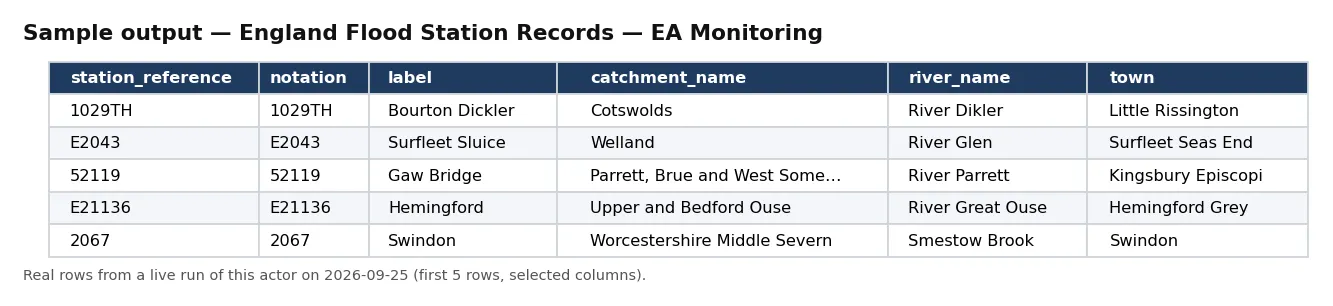
Real rows from a live run of this actor (first 5 rows, selected columns).
One full record from the same run, exactly as delivered:
Pricing
| Event | Free plan | Bronze | Silver | Gold / Platinum / Diamond |
|---|---|---|---|---|
station_record | $0.05 | $0.045 | $0.04 | $0.0335 |
Delivered before charged. Blocked runs and empty results cost nothing.
Input
| Field | Type | Default | Description |
|---|---|---|---|
catchmentContains | string | — | Optional. Keep only stations whose catchment name contains this text. |
riverContains | string | — | Optional. Keep only stations whose river name contains this text. |
townContains | string | — | Optional. Keep only stations whose town contains this text. |
maxRecords | integer | 10 | Ceiling on records delivered and billed. |
Default changed on 30 Sep 2026: if you leave maxRecords out, a run now returns up to 10 records (it was 500). Set maxRecords yourself to get more — the maximum is unchanged.
Output
One JSON object per station. Real example (values as published):
An unbilled RUN_RECEIPT records the robots check, the filters, rows seen and delivered, and whether charged equals delivered.
Field reference
Each record is one monitoring station. Identity: record_id / notation, station_reference, label, rloi_id, and wiski_id. Location: catchment_name, river_name, town, lat, long, easting, and northing. Operation: status, date_opened, and measure_count (how many measures the station reports). Reference: station_url. Provenance: source, source_url, licence, attribution, disclaimer, and observed_at.
How a run works
A run first re-reads the source host's robots posture from your runtime — the Environment Agency data host, which disallows /data/ and /doc/ but leaves the /flood-monitoring/ path clear — and stops at the door if that ever changes. It then pages the stations endpoint, applies your optional catchment, river, and town filters, and flattens each station to one record — reading only station and location fields, never anything person-shaped — delivered before it is charged, so a blocked or empty run costs you nothing. The actor stops at your maxRecords ceiling and records charge_equals_delivered in the receipt.
Coverage and scope
The register holds on the order of 5,500+ monitoring stations across England's catchments and rivers. Because each record carries the catchment_name and river_name, segmenting the network by catchment or river is a single filter, and the coordinates place every station on a map. Pull one catchment to build a regional inventory, or the whole register to seed a national gauge map, then join to the EA's live measures service on the station reference for readings.
Working with the station network
Each station is a join key, not an endpoint. The station_reference and notation are the identifiers the Environment Agency's live measures and readings services use, so a station record pulled here links directly to real-time level and flow data on the same reference — this actor gives you the stable inventory to hang those time series on. The catchment_name and river_name let you roll individual gauges up to a catchment or a river for basin-level coverage analysis, and the easting/northing and lat/long pairs place every station precisely on either an OSGR or a WGS84 map without a separate geocoding step. Because the register changes slowly — stations open and close occasionally rather than constantly — a periodic pull keeps a downstream inventory current with a small, cheap refresh rather than a full re-ingest.
Cost guidance
One station_record per delivered station: cost = stations delivered × your plan's per-record price. Scope with catchmentContains, riverContains, or townContains to keep runs bounded. The whole register is ~5,500 stations; 1,000 stations is $50 (Free) / $33.50 (Gold), and the complete network is well under $300 at Gold as a one-time seed.
Honest limitations
- A register, not a reading. These are station records, not live water levels or flood warnings; join to the EA's live measures service for readings.
- As published. Station attributes and coordinates are exactly as the API distributes them; this actor reformats, it does not interpret.
- England coverage. The flood-monitoring network covers England.
- No person data of any kind.
Differentiation
It is distinct from any US flood-insurance or hazard cell (which carry claims or events, not the England gauge register) and from the fleet's emissions and environmental-facility cells. Its specific job is the Environment Agency flood-monitoring station register — the infrastructure map that hydrology and flood-risk systems join their readings against.
The NexGen Signal family
Part of the NexGen Signal family of pay-per-record data products:
- EU Industrial Emissions Records — EEA IED Facilities
- Natural Hazard Event Records — NASA EONET
- Storm Event Records — NOAA/NCEI
- Air Quality Monitor Records — US EPA AQS
- UK Company Status Records — Companies House
Source: UK Environment Agency flood-monitoring API (environment.data.gov.uk). Contains public sector information licensed under the Open Government Licence v3.0 (declared by the API) — free to reuse, including commercially, with attribution. Station / infrastructure grain; no person data of any kind. Station register, not a live flood reading or warning.


