

NOAA Tropical Cyclone Best-Track Records - HURDAT2
Pricing
from $33.50 / 1,000 track-fix records
NOAA Tropical Cyclone Best-Track Records - HURDAT2
NOAA NHC HURDAT2 tropical-cyclone best-track database (Atlantic + NE/Central Pacific) as clean per-fix records - position, status, wind, pressure and wind radii, stamped with storm id, name and basin. Public domain. $0.05 per record.
Pricing
from $33.50 / 1,000 track-fix records
Rating
0.0
(0)
Developer
NexGen Signal
Maintained by CommunityActor stats
0
Bookmarked
2
Total users
1
Monthly active users
13 hours ago
Last modified
Categories
Share
NOAA's HURDAT2 tropical-cyclone best-track database - the National Hurricane Center's official post-storm reanalysis - as clean, per-fix records. One row per best-track fix (a cyclone's position and intensity at a synoptic or special time), carrying its storm id, storm name and basin, across the North Atlantic and NE/Central Pacific basin files.
What one record represents
The source is NOAA NHC HURDAT2, published as two basin text files. Each file lists storms as a header
line - storm id, name and number of fixes - followed by that many track-fix lines. This Actor parses the
header/child structure and emits one record per track fix, stamping each fix with its storm's id, name
(UNNAMED where none was assigned), basin and season year. Each record carries the fix date and UTC time, a
record identifier (e.g. L for landfall), the system status (HU, TS, TD, EX, SD, SS, LO, WV, DB), latitude
and longitude (verbatim and as signed decimal degrees), maximum sustained wind, minimum central pressure, the
34/50/64-knot wind radii in all four quadrants, and the radius of maximum wind.
Sample output
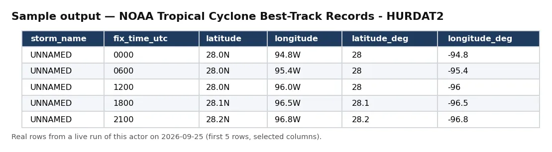
Real rows from a live run of this actor (first 5 rows, selected columns).
One full record from the same run, exactly as delivered:
Coverage and volume
The two basin files, in their 2025-season editions (revised 27 February 2026), together carry
87,631 track fixes - 55,605 in the North Atlantic file (hurdat2-1851-2025-02272026.txt, seasons
1851-2025) and 32,026 in the NE/Central Pacific file (hurdat2-nepac-1949-2025-02272026.txt, seasons
1949-2025). Those counts were measured live from the files fetched at build time.
Sol's Wave-3 index put this door at about 87,631 track-fix rows; measured live at build time the two basin files carry exactly 87,631 fixes (55,605 Atlantic + 32,026 NE/Central Pacific).
Both editions were confirmed as the newest published files in the NHC HURDAT directory at build time. The Actor delivers the fixes in file order (storm by storm, fix by fix) and stops as soon as your Maximum records cap is met.
Format and parsing
The record layout is quoted from the NHC HURDAT2 format document (https://www.nhc.noaa.gov/data/hurdat/hurdat2-format-atl-1851-2021.pdf). A header line reads, verbatim from that document:
AL (Spaces 1 and 2) - Basin - Atlantic; 09 - ATCF cyclone number for that year; 2021 - Year; IDA - Name, if available, or else "UNNAMED"; 40 - Number of best track entries - rows - to follow
and each data line carries date (YYYYMMDD), time (HHMM UTC), record identifier, status, latitude, longitude,
maximum sustained wind (knots), minimum pressure (mb), the 34/50/64-knot wind radii (NE, SE, SW, NW), and the
radius of maximum wind. Where the source records -999/-99 (missing), the Actor delivers null. The
radius of maximum wind exists only from the 2021 season onward and is null before then.
Licence and attribution
HURDAT2 is a U.S. Government work in the public domain (17 U.S.C. 105) - no copyright. The full notice, including the NWS/NOAA disclaimer, travels on every record:
U.S. Government work - NOAA National Hurricane Center HURDAT2 best-track database. Public domain (17 U.S.C. 105); no copyright. NWS/NOAA disclaimer: provided 'as is' with no warranty; not for use as the sole basis for safety-of-life decisions. Attribution to NOAA/NHC requested.
Attribution to NOAA/NHC is requested and stamped on every record. The data is provided "as is"; it is a historical reanalysis, not a real-time or safety-of-life product.
Person-data policy
HURDAT2 carries no personal data. Storm names are tropical-cyclone names (or UNNAMED, or a number such
as "TEN"), never persons; a per-record assertion rejects any forecaster/analyst/person field (verified with a
planted-field test). No natural-person data is processed.
Interpretation caveat
One record per best-track fix across the North Atlantic (AL) and NE/Central Pacific (EP) basin files, each in its 2025-season edition (revised 27 Feb 2026). Every fix carries its storm id, name (UNNAMED where none assigned; never a person) and basin. Wind radii and pressure use null where the source records -999/-99 (missing). Radius of maximum wind exists only from the 2021 season onward.
Values are reproduced verbatim from the best-track files; the Actor never rewrites a field. Latitude and
longitude are delivered both as the source's verbatim strings (e.g. 28.0N, 94.8W) and as signed decimal
degrees for direct numeric use. A fix's record_identifier is blank for ordinary synoptic times and set (for
example L) at landfalls and intensity maxima.
Data quality and freshness
Wind, pressure, the twelve wind-radii fields and the radius of maximum wind are delivered as real numbers
(null where missing); latitude/longitude have both string and numeric forms. The record_id composes storm
id, date, time and a per-storm sequence, so every fix is uniquely keyed and the dataset is safe to diff,
deduplicate or upsert. HURDAT2 is republished on NHC's post-season reanalysis cycle; re-running the Actor
picks up new seasons and any reanalysis revisions, and each record's observed_at stamp dates the snapshot.
The run's RUN_RECEIPT records the source URLs, how many records were delivered and charged, and confirms
charge_equals_delivered.
Provenance and compliance
Every run reads www.nhc.noaa.gov/robots.txt at runtime; the gate result (URL, status, byte length, SHA-256
of the policy) is written to the run's RUN_RECEIPT, and both basin file paths are confirmed crawlable before
any fetch. The Actor never bypasses a block or fetches through a mirror.
Inputs
- Maximum records (
maxRecords) - hard cap on track-fix records delivered and billed. You are billed only for records actually delivered. The two files together carry ~87,600 fixes.
Output
Records land in the Actor's default dataset and export as JSON, CSV, Excel or via the Apify API. A tabular overview view surfaces storm id, storm name, basin, fix date/time, status, latitude, longitude, maximum wind and minimum pressure.
Fields in detail
The record leads with record_id, storm_id, storm_name, basin, basin_name and storm_year, then the
fix: fix_date, fix_time_utc, record_identifier, status, latitude/longitude (verbatim) and
latitude_deg/longitude_deg (signed decimals), max_wind_kt, min_pressure_mb, the twelve wind-radii
columns (r34_ne ... r64_nw) and radius_max_wind_nm. The provenance block closes every record. Because
each record carries its storm id and basin, you can regroup the fixes into storm tracks or aggregate to
per-storm intensity with a single group-by.
Scaling and limits
Set Maximum records low to sample cheaply or high to pull the full best-track history. The Actor streams
the two files and delivers incrementally, so memory stays flat, and you are billed only for what is delivered.
Because HURDAT2 is a fixed historical reanalysis republished each post-season, re-running keeps a downstream
climatology current with new seasons and revisions, and each record's observed_at stamp dates the snapshot.
To build a per-storm panel, group the fixes on storm_id; to compare basins, filter on basin.
Typical uses
Insurance, catastrophe-modelling and climatology teams use this cell as the authoritative track history for
Atlantic and eastern-Pacific cyclones - one flat table of every reanalysed fix, with intensity and wind
structure, that regroups into storm tracks on storm_id or aggregates to per-storm peak intensity with a
single group-by. Because latitude and longitude come as signed decimals, the fixes drop straight into a GIS
or a spatial join against exposure data, and the landfall record identifier isolates the fixes that matter
for coastal impact. Researchers use the full 1851-onward Atlantic record for long-period trend work, with
the caveat that pre-satellite seasons carry more missing wind-radii and pressure values (delivered as null,
never as a guessed number). A scheduled run keeps a downstream climatology current as NHC publishes each
post-season reanalysis.
Sibling Actors
It sits beside the fleet's NOAA Storm Events database records and natural-hazard event records, which are distinct datasets (event catalogues, not best-track fixes). It shares its text-file engineering - the runtime robots gate, verbatim-value discipline and push-then-charge billing - with the fleet's other NOAA records Actors, from which it stays distinct as a best-track fix feed (position/intensity every few hours) rather than an event catalogue.


