

NOAA Storm Events Locations
Pricing
from $13.40 / 1,000 storm location records
NOAA Storm Events Locations
Structured storm-event location points from the U.S. NOAA/NCEI Storm Events Database, read directly from the official public bulk directory (www.ncei.noaa.gov/pub/data/swdi/stormevents/csvfiles/).
Pricing
from $13.40 / 1,000 storm location records
Rating
0.0
(0)
Developer
NexGen Watch
Maintained by CommunityActor stats
0
Bookmarked
2
Total users
1
Monthly active users
19 hours ago
Last modified
Categories
Share
🔔 NOAA Storm Events Locations
Structured storm-event location points from the U.S. NOAA/NCEI Storm Events Database, read directly from
the official public bulk directory (www.ncei.noaa.gov/pub/data/swdi/stormevents/csvfiles/). One record per row
of the annual locations file, streamed by incremental gunzip and carried source-native and verbatim —
the raw coordinates (latitude, longitude, lat2, lon2), range and azimuth (bearing) exactly as NOAA
publishes them. The record key is event_id + location_index.
Output is one storm_location_record row per result; billing is pay-per-event, the value event being one storm location record (a $0.02 start fee per run, then $0.02 per storm location record). Source: www.ncei.noaa.gov.
No login, no API key and no CAPTCHA solving are involved: the source is read logged-out with an identified contact User-Agent.
📊 Sample Output
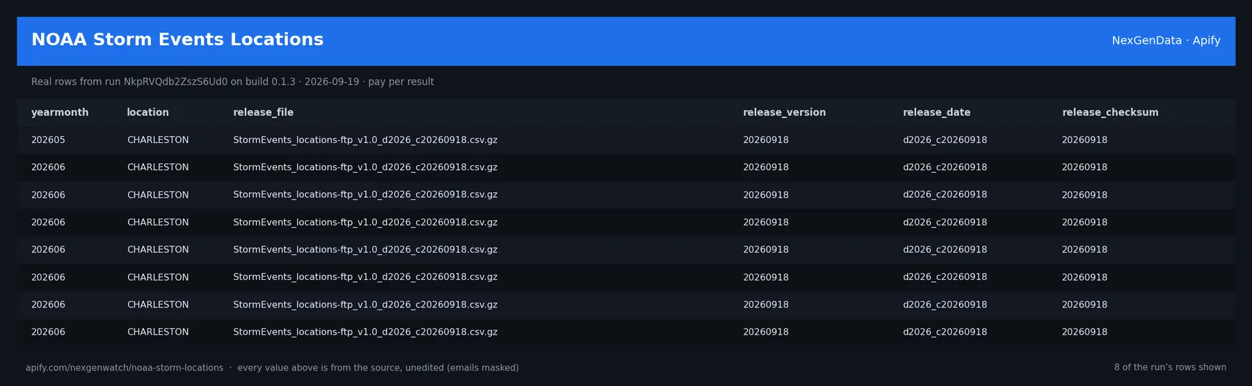
Real rows from run Vr1gsgKLZCgGFs2xv on build 0.1.5 (2026-09-19), the same input as the Quick start below — every value is as the source published it (emails masked, long text shortened):
| yearmonth | location | release_file | release_version | release_date | release_checksum |
|---|---|---|---|---|---|
| 202605 | CHARLESTON | StormEvents_locations-ftp_v1.0_d2026_c20260918.csv.gz | 20260918 | d2026_c20260918 | 20260918 |
| 202606 | CHARLESTON | StormEvents_locations-ftp_v1.0_d2026_c20260918.csv.gz | 20260918 | d2026_c20260918 | 20260918 |
| 202606 | CHARLESTON | StormEvents_locations-ftp_v1.0_d2026_c20260918.csv.gz | 20260918 | d2026_c20260918 | 20260918 |
| 202606 | CHARLESTON | StormEvents_locations-ftp_v1.0_d2026_c20260918.csv.gz | 20260918 | d2026_c20260918 | 20260918 |
| 202606 | CHARLESTON | StormEvents_locations-ftp_v1.0_d2026_c20260918.csv.gz | 20260918 | d2026_c20260918 | 20260918 |
| 202606 | CHARLESTON | StormEvents_locations-ftp_v1.0_d2026_c20260918.csv.gz | 20260918 | d2026_c20260918 | 20260918 |
| 202606 | CHARLESTON | StormEvents_locations-ftp_v1.0_d2026_c20260918.csv.gz | 20260918 | d2026_c20260918 | 20260918 |
| 202606 | CHARLESTON | StormEvents_locations-ftp_v1.0_d2026_c20260918.csv.gz | 20260918 | d2026_c20260918 | 20260918 |
The run finished with the status message: NORMAL: 17 unique rows (0 duplicates collapsed) from d2026_c20260918. billable=17
✅ What you get
Each row is flat JSON with these fields (from the dataset schema and the sample run; a field the source does not publish for a given row is null):
record_type(string/null) — e.g.storm_location_recordyearmonth(string/null) — e.g.202605episode_id(string/null) — e.g.211957event_id(string/null) — e.g.1337802location_index(string/null) — e.g.1range(string/null) — e.g..24azimuth(string/null) — e.g.SElocation(string/null) — e.g.CHARLESTONlatitude(string/null) — e.g.41.7672longitude(string/null) — e.g.-77.2473lat2(string/null) — e.g.4146032lon2(string/null) — e.g.7714838provenance(string/null) — e.g.NOAA/NCEI Storm Events Database (locations file); coordinates carried source-natgeometry_note(string/null) — e.g.point coordinates, RANGE and AZIMUTH are carried EXACTLY as NOAA publishes them;release_file(string/null) — e.g.StormEvents_locations-ftp_v1.0_d2026_c20260918.csv.gzrelease_year(string/null) — e.g.2026release_version(string/null) — e.g.20260918partial_year_file(boolean/null) — e.g.Truepartial_year_note(string/null) — e.g.the 2026 annual file is an IN-PROGRESS (incomplete) year — NOAA is still collectsource_url(string/null) — e.g.https://www.ncei.noaa.gov/pub/data/swdi/stormevents/csvfiles/StormEvents_locatiorecord_key(string/null) — e.g.1337802|1source(string/null) — e.g.noaa-storm-locationsrelease_date(string/null) — e.g.d2026_c20260918observed_at(string/null) — e.g.2026-09-19T04:50:00Zrelease_checksum(string/null) — e.g.20260918license(string/null) — e.g.U.S. NOAA National Centers for Environmental Information (NCEI), Storm Events Daattribution(string/null) — e.g.NOAA National Centers for Environmental Information (NCEI) — Storm Events Databaterminal(string/null) — null in every sample rowscope(string/null) — null in every sample rownote(string/null) — null in every sample rowreported_total(string/integer/null) — null in every sample rowraw_seen(string/integer/null) — null in every sample rowduplicates(string/integer/null) — null in every sample rowunique_found(string/integer/null) — null in every sample rowdelivered(string/integer/null) — null in every sample row
✅ What you get
record_type(string/null) — e.g.storm_location_recordyearmonth(string/null) — e.g.202605episode_id(string/null) — e.g.211957event_id(string/null) — e.g.1337802location_index(string/null) — e.g.1range(string/null) — e.g..24azimuth(string/null) — e.g.SElocation(string/null) — e.g.CHARLESTONlatitude(string/null) — e.g.41.7672longitude(string/null) — e.g.-77.2473lat2(string/null) — e.g.4146032lon2(string/null) — e.g.7714838provenance(string/null) — e.g.NOAA/NCEI Storm Events Database (locations file); coordinates carried source-natgeometry_note(string/null) — e.g.point coordinates, RANGE and AZIMUTH are carried EXACTLY as NOAA publishes them;release_file(string/null) — e.g.StormEvents_locations-ftp_v1.0_d2026_c20260918.csv.gzrelease_year(string/null) — e.g.2026release_version(string/null) — e.g.20260918partial_year_file(boolean/null) — e.g.Truepartial_year_note(string/null) — e.g.the 2026 annual file is an IN-PROGRESS (incomplete) year — NOAA is still collectsource_url(string/null) — e.g.https://www.ncei.noaa.gov/pub/data/swdi/stormevents/csvfiles/StormEvents_locatiorecord_key(string/null) — e.g.1337802|1source(string/null) — e.g.noaa-storm-locationsrelease_date(string/null) — e.g.d2026_c20260918observed_at(string/null) — e.g.2026-09-19T04:23:54Zrelease_checksum(string/null) — e.g.20260918license(string/null) — e.g.U.S. NOAA National Centers for Environmental Information (NCEI), Storm Events Daattribution(string/null) — e.g.NOAA National Centers for Environmental Information (NCEI) — Storm Events Databaterminal(string/null) — null in every sample rowscope(string/null) — null in every sample rownote(string/null) — null in every sample rowreported_total(string/integer/null) — null in every sample rowraw_seen(string/integer/null) — null in every sample rowduplicates(string/integer/null) — null in every sample rowunique_found(string/integer/null) — null in every sample rowdelivered(string/integer/null) — null in every sample row
What you get
One storm_location_record per locations row — all NOAA columns carried verbatim (yearmonth, episode_id,
event_id, location_index, range, azimuth, location, latitude, longitude, lat2, lon2) plus
provenance, geometry_note, release_file, release_year, release_version, partial_year_file,
partial_year_note, source_url. A column canary fails loud on header drift.
⚙️ Sample inputs
1. Quick start — the Store example (this is what the sample above came from)
The sample run charged exactly: 1 × $0.02 apify-actor-start + 17 × $0.02 storm_location_record = $0.36 on the Free tier — every delivered row was billed.
2. A smaller, narrowed run
Caps the run at 5 rows — about $0.12 on the Free tier ($0.02 start + 5 × $0.02).
3. A full-size run
Up to 2500 rows (the schema default for maxRecords) — about $50.02 on the Free tier ($0.02 start + 2500 × $0.02) if the source has that many.
4. A filtered run
Keeps only rows whose azimuth contains SE (a value from the sample run above), matched case-insensitively after the source is read and before the maxRecords cap, so the cap counts matches and only delivered matches are billed. searchText does the same across every column. Zero matches end the run as EMPTY_SELECTION with no row charged — if the source has moved on since that sample run, pick a value you see in your own first run. The source is still read in full — this narrows what you receive and pay for, not what the source serves.
🧾 JSON sample record
One real record from run Vr1gsgKLZCgGFs2xv, exactly as it lands in the dataset (emails masked, long text shortened):
🔧 How it works
Source. The actor reads www.ncei.noaa.gov — endpoints: https://www.ncei.noaa.gov/pub/data/, https://www.ncei.noaa.gov/pub/data/swdi/stormevents/csvfiles/. Public pages and feeds only; nothing behind a login.
Transport. Plain HTTPS from the Apify platform, no proxy. robots.txt is read first and a disallowed path is never fetched. Every request carries an identified contact User-Agent. Pacing: CRAWL_DELAY=0.0.
Terminal states. A run ends NORMAL, CAPPED (your cap was reached), PARTIAL (something was withheld and the message says what), GENUINE_EMPTY (the source was read and truly had nothing in scope) or BLOCKED (the source refused or changed shape — the run FAILS loud and bills nothing). A zero-row run is never reported as a silent success.
Charging. Each storm location record is charged at the moment it is pushed (storm_location_record); a row that fails to charge is not delivered, so the dataset count always equals the charged count.
🔧 How it works
No geometry is ever inferred
This actor carries the point coordinates, range and bearing exactly as published. It never derives a
polygon, an affected radius, a footprint, an impact area, or any spatial extent from them — range/azimuth
are NOAA's point-to-nearest-place bearing, not a hazard radius. A geometry_note records this on every
record.
Person-level fatality data is NEVER read
This actor reads only the locations file. It never fetches, constructs, or parses the
StormEvents_fatalities-* file — the person-level fatality table (age, sex, location of death). The file
resolver refuses any fatalities member, and no code path anywhere builds a fatalities URL. The locations
file carries no person-level data — only event geo-points.
Latest annual file, in-progress years, and pinning a year
The actor discovers the latest versioned annual locations file from the directory each run. NOAA is a
living source: the default resolves the newest file even when that is the current, in-progress year.
Every record from an in-progress-year file carries partial_year_file = true and a partial_year_note
saying NOAA is still collecting/revising that year. Pin a complete year with the year input (e.g. "2025")
for a finalized dataset.
Filters
Supply at least one of eventIds, episodeIds, or locations — the annual file is never emitted in full.
maxRecords caps delivery (one charge per delivered record, hard cap 5000); maxScanRows bounds the scan.
Robots & door
www.ncei.noaa.gov/robots.txt disallows /data* and /orders*. This actor fetches only under /pub/data/
(which is not under /data* and is permitted) and never anything else. Robots is re-read every run and the actor
STOPs (fails, charges nothing) on any real Disallow covering the path. NOAA/NCEI acknowledgement; no implied NOAA
endorsement.
Source & licence
U.S. NOAA National Centers for Environmental Information (NCEI), Storm Events Database — U.S. Government work, public domain. Acknowledgement: data from NOAA/NCEI (https://www.ncei.noaa.gov/pub/data/swdi/stormevents/csvfiles/).
What is not done. No login, no cookie or CAPTCHA bypass, no private or personal-account data, no browser automation.
💰 Pricing example
| Event | Free | Bronze | Silver | Gold |
|---|---|---|---|---|
Actor Start (apify-actor-start) | $0.02 | $0.02 | $0.02 | $0.02 |
Storm location record (storm_location_record) | $0.02 | $0.018 | $0.016 | $0.0134 |
Worked at the live Free-tier price:
- 8 storm location records: $0.02 start + 8 × $0.02 = $0.18
- 25 storm location records: $0.02 start + 25 × $0.02 = $0.52
- 2500 storm location records: $0.02 start + 2500 × $0.02 = $50.02
A run that delivers zero rows charges the $0.02 start fee only. A BLOCKED run (source refused) fails loud and charges no value event. The start fee is charged once per GB of run memory; the default run memory is 4096 MB.
Yield on the sample run: NORMAL: 17 unique rows (0 duplicates collapsed) from d2026_c20260918. billable=17. maxRecords is a hard ceiling on what is delivered and billed, never a target.
⚖️ Legal & ToS
This actor reads public, logged-out pages and feeds published by www.ncei.noaa.gov. It collects only what the source publishes to any visitor, keeps to the source's robots rules (checked on every run), identifies itself with a contact User-Agent, and does not access accounts, private data or anything behind authentication. Use the output in line with the source's terms and your local law; the intended use is B2B research and monitoring.
❓ FAQ
Q: Do I need an API key or a login?
A: No. The source (www.ncei.noaa.gov) is read logged-out; the input schema has no key field and the actor carries no secrets.
Q: Why did my run return 0 rows?
A: Read the run's status message. GENUINE_EMPTY means the source was read and had nothing in scope for your input; BLOCKED means the source refused and the run failed without billing a value event — retry later or narrow the input. A zero-row run bills the start fee only.
Q: How many rows can one run return?
A: Up to maxRecords (default 2500). Raise the cap for a bigger run; you pay per delivered row.
Q: How fresh is the data?
A: Every run reads the source live at run time; nothing is cached between runs. Put it on a schedule for a continuous feed.
Q: What formats can I export?
A: The dataset downloads as JSON, CSV, Excel, XML or RSS from the run's Dataset tab or the Apify API, and any run can push to a webhook or integration.
Q: How is this different from the other NexGen Watch actors actors?
A: Same output shape and billing model; this one covers www.ncei.noaa.gov. The siblings under Related Actors cover the other sources or slices — run several on one schedule for a combined feed.
Q: Are there rate limits?
A: The actor paces itself against the source (CRAWL_DELAY=0.0) and honours its robots rules; there is no per-buyer limit beyond your Apify plan's concurrency.
🆘 Troubleshooting
- Run FAILED with BLOCKED → the source refused the request or changed its page shape → nothing was billed beyond the start fee; retry after a while, and if it persists open an Issue with the run id.
- Status says CAPPED → your cap (
maxRecords) was reached → raise it for a bigger run. - Input validation error on start → a field is outside the schema's allowed values → start from the Quick start block and change one field at a time.
- Run TIMED-OUT → a very wide request on a slow day → raise the run timeout in Run options or narrow the input; what was delivered before the timeout is still in the dataset.
🔗 Related Actors
- NOAA ISD Hourly Surface Observations — Structured hourly surface weather observations from the U.S. NOAA/NCEI Integrated Surface Database (ISD), read directly from the official public bulk…
- NOAA Storm Damage & Impact Feed — A deterministic impact subset of the U.S. NOAA/NCEI Storm Events Database details file — only storm events with a published impact are emitted
- NOAA Storm Events Database Scraper — Scrape the NOAA Storm Events Database: event type, location, date, damage and casualties. One record per result. Pay per result
- NY OCM Licence Registry — One ocm_licence_record per licence or application: entity name, DBA, licence type, status (label AND source status code preserved verbatim), see-cate…
- NYC DCWP Business Licence Registry — One business_licence_record per DCWP licence: licence number, business + DBA name, category, type, status, creation/expiration dates, contact phone,…
- New Zealand Charities Register — One structured charity_record per registered organisation from New Zealand's official Charities Register — keyless, logged-out, CC BY 3.0 NZ
- 🏢 About NexGenData — NexGen Watch is NexGenData's fleet of more than 300 public data actors built on official sources, pay-per-result. Browse the catalog at apify.com/nexgenwatch.
⭐ Found this useful?
If this actor saved you a manual check, a quick review on the Apify Store helps other teams find it. Feature request or a source that changed? Open it from the Issues tab — every one is read.


