
USGS Earthquake Intelligence
Pricing
from $2.40 / 1,000 usgs earthquake intelligence records
USGS Earthquake Intelligence
Official USGS earthquake events with time, radius, bounding-box, magnitude, depth, review, PAGER, tsunami, quality and source evidence. Export normalized records and run summaries, use the API, schedule monitoring, or connect integrations and agent workflows.
Pricing
from $2.40 / 1,000 usgs earthquake intelligence records
Rating
0.0
(0)
Developer

Skootle
Maintained by CommunityActor stats
0
Bookmarked
2
Total users
1
Monthly active users
22 days ago
Last modified
Categories
Share
USGS Earthquake Intelligence
TL;DR: what does this Actor give you?
USGS Earthquake Intelligence turns the official United States Geological Survey FDSN Event API into monitoring-ready, analysis-ready, and agent-ready records. Query by time, map area, radius, magnitude, depth, review status, felt reports, significance, product type, event type, or PAGER alert level. Every earthquake row includes concrete fields such as eventId, time, updated, magnitude, depthKm, latitude, longitude, place, status, alert, significance, felt, tsunami, nst, gap, rms, dmin, sources, types, fieldCompletenessScore, sourceUrl, and agentMarkdown.
Every query also returns one SUMMARY record and one AGENT_BRIEFING record. The summary reports magnitude and depth statistics, alert distributions, tsunami flags, review status, event types, query provenance, and a stable query fingerprint. A genuine no-match query returns an explicit zero-result summary. A broken response, malformed payload, or source failure stops the run instead of billing you for a silent empty dataset.
Run it from the Apify Console, call it through the API, schedule it for recurring monitoring, or connect its dataset to Make, Zapier, n8n, webhooks, databases, notebooks, maps, and agent workflows.
If this Actor saves you time, leave a review. Reviews help other buyers find reliable USGS data tools.
What can you use USGS Earthquake Intelligence for?
Use this Actor when raw earthquake feeds are not enough and you need a repeatable query, consistent fields, transparent source evidence, and a run-level briefing. Common uses include:
- Earthquake and aftershock monitoring for a defined region.
- Insurance, catastrophe modeling, and exposure research.
- Infrastructure, logistics, utility, and supply-chain watchlists.
- Newsroom and public-safety research using official event data.
- Academic seismology projects that need normalized GeoJSON fields.
- Travel, facility, and operational risk dashboards.
- Tsunami and PAGER alert screening.
- Quality analysis using
nst,gap,rms, anddmin. - Dataset enrichment for maps, reports, alerts, and retrieval systems.
- Scheduled API jobs that compare current results with a prior run.
- Agent workflows that need concise Markdown plus structured numeric fields.
The source is the official USGS FDSN Event API. No browser, residential proxy, scraping vendor, or private key is required.
Why use this instead of downloading raw USGS GeoJSON?
The USGS API is excellent, but its response is designed as a scientific event feed rather than a buyer-ready workflow product. You still have to validate inputs, paginate, deduplicate, normalize nullable values, preserve provenance, calculate summary statistics, distinguish a valid zero from a broken response, and prepare records for your downstream tools.
This Actor handles that work in one run:
- It validates the query before contacting USGS.
- It maps readable input names to the official FDSN parameters.
- It retrieves bounded GeoJSON pages from the official endpoint.
- It validates the feature collection and every event geometry.
- It deduplicates events by the stable USGS event ID.
- It normalizes coordinates, magnitude, dates, review state, quality fields, and impact fields.
- It adds stable IDs, numeric mirrors, ISO dates, source links, a schema version, and a query fingerprint.
- It calculates run-level magnitude, depth, tsunami, alert, review, and event-type summaries.
- It writes one plain-language briefing for agents and analysts.
- It fails closed when the source response cannot support a trustworthy result.
You get consistent records without hiding the official source. Each earthquake row retains a direct USGS event URL so you can verify the latest scientific details.
Which USGS filters are supported?
The input covers the high-value FDSN Event API filters used in monitoring and research:
Time filters
startTime: earliest event time as an ISO date or date-time.endTime: latest event time as an ISO date or date-time.updatedAfter: return events updated after a specific timestamp.
Radius filters
latitudeandlongitude: the center point.maxRadiusKm: maximum radius in kilometers.maxRadiusDegrees: maximum angular radius.
Latitude and longitude must be supplied together. Choose kilometers or degrees, not both.
Bounding-box filters
minLatitudeandmaxLatitude.minLongitudeandmaxLongitude.
Bounding boxes work well for states, countries, coastlines, pipeline corridors, and other fixed operating regions.
Event filters
minMagnitudeandmaxMagnitude.minDepthandmaxDepthin kilometers.eventType, such asearthquakeorquarry blast.reviewStatus, eitherautomaticorreviewed.minSignificancefor the USGS significance score.minFeltfor the minimum number of felt reports.productType, such asshakemapormoment-tensor.alertLevel, one ofgreen,yellow,orange, orred.maxResults, capped at 5,000 earthquake rows per run.
The Actor sorts by newest event time and returns only the bounded number of rows you request. SUMMARY and AGENT_BRIEFING are added separately and do not consume the earthquake limit.
What fields does each earthquake record include?
Every EARTHQUAKE record uses schema version 1.0.0 and includes:
- Identity:
id,eventId,recordType,schemaVersion. - Provenance:
source,sourceUrl,detailUrl,retrievedAt,queryFingerprint. - Time:
time,updated,timeEpochMs,updatedEpochMs. - Location:
latitude,longitude,depthKm,place,title. - Magnitude:
magnitude,magnitudeType. - Source state:
status,eventType,net,code. - Impact:
alert,pagerAlert,significance,felt,cdi,mmi,tsunami,tsunamiNumeric. - Scientific quality:
nst,gap,rms,dmin. - Product references:
ids,sources,types. - Workflow fields:
fieldCompletenessScore,agentMarkdown.
Nullable source fields remain null rather than becoming misleading zeroes. Numeric values stay numeric. Dates are mirrored as ISO strings and epoch milliseconds where available.
What is in the SUMMARY and AGENT_BRIEFING records?
The SUMMARY record answers the questions a buyer normally calculates after export:
- How many events matched?
- What was the minimum, maximum, mean, and median magnitude?
- What was the minimum, maximum, mean, and median depth?
- How many events carried a tsunami flag?
- How many events had green, yellow, orange, or red alerts?
- Which event types appeared?
- Which records were automatic or reviewed?
- Which exact query produced the dataset?
- When was the source retrieved?
- What stable fingerprint identifies the query configuration?
The AGENT_BRIEFING record mirrors the important run facts in concise Markdown. It is useful for LLM tools, monitoring summaries, incident intake, and human review without forcing an agent to summarize hundreds of raw records first.
Does the Actor distinguish no results from a broken source?
Yes. This is a core reliability feature.
A valid query that matches no events returns exactly two rows: one zero-result SUMMARY and one zero-result AGENT_BRIEFING. Both state sourceStatus: "no_match", preserve the query, and report a count of zero.
The Actor does not treat these conditions as a healthy empty result:
- HTTP errors from the USGS endpoint.
- Network or timeout failures.
- Malformed JSON.
- A changed feature collection shape.
- Events without valid point geometry.
- A source response that reports matches but yields an empty page.
- Normalization that unexpectedly produces no usable records from a nonempty response.
Those states write DEBUG_ZERO_PARSE.json to the key-value store and fail the Actor run. This protects scheduled monitoring and keeps a source problem from looking like a quiet day.
Real verification examples
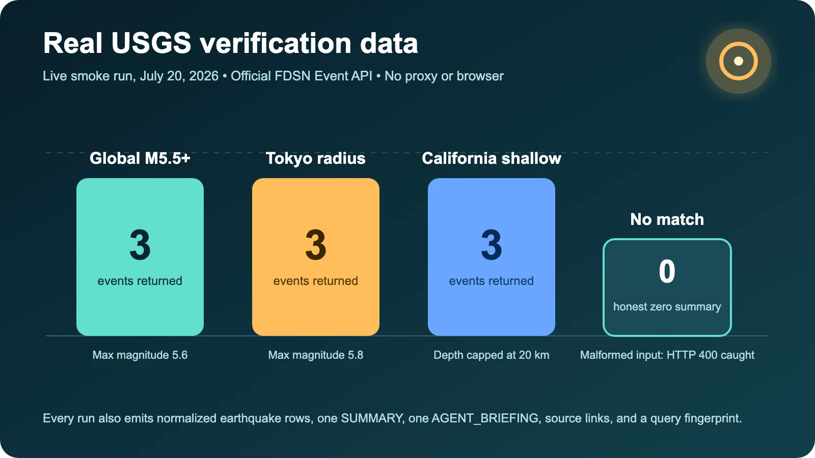
These examples come from the live USGS smoke run captured on July 20, 2026. They are not invented placeholder rows.
Example 1: recent global earthquakes at magnitude 5.5 or higher
Input:
The run returned three real earthquake rows plus one summary and one briefing. The first returned event was us7000t1w2, magnitude 5.6, depth 10 km, located 208 km southwest of Port McNeill, Canada. Its official source was https://earthquake.usgs.gov/earthquakes/eventpage/us7000t1w2.
Example 2: Tokyo radius monitoring
Input:
The run returned three events. The highest magnitude in the sample was 5.8 near Yokoshiba, Japan. The dataset also included a magnitude 5.2 event near Otsuki and a magnitude 5.3 event near Koga. Every row retained its official USGS event page.
Example 3: shallow California-region events
Input:
The run returned three events with depths at or below 20 km. One real row was event ci41292687, magnitude 4.31762677888687, depth 7.55 km, 18 km west-southwest of Johannesburg, California. Keeping the full numeric magnitude supports accurate downstream calculations while the human-readable briefing can round for display.
Example 4: honest zero result
Input:
USGS returned a valid empty feature collection. The Actor produced zero earthquake rows, one SUMMARY, and one AGENT_BRIEFING. The run completed successfully with sourceStatus: "no_match" rather than pretending that an API failure occurred.
Example 5: malformed source request containment
The live smoke suite also called the official endpoint with an invalid format value. USGS returned HTTP 400. The check passed only because the failure was observed and contained. Production runs follow the same rule: malformed or unavailable source responses fail closed.
How do I run the Actor in Apify Console?
- Open the Actor input page.
- Choose a time window.
- Add a magnitude threshold, region, radius, or impact filter.
- Set
maxResultsto a bounded number appropriate for your workflow. - Click Start.
- Open the Dataset tab for earthquake rows, the summary, and the briefing.
- Open the Key-value store to download
AGENT_BRIEFING.mdor inspect debug evidence after a failed source run.
A good first run is the prefilled input:
How do I call it through the Apify API?
Run the Actor synchronously:
For production integrations, keep your Apify token in a secret store. Do not embed it in browser code, public repositories, or client-side logs.
You can also start a run asynchronously, store the run ID, wait for completion, and download the default dataset. That pattern is useful for larger scheduled jobs and webhook-driven pipelines.
How do I schedule earthquake monitoring?
Create an Apify Schedule and reuse a stable query. Examples:
- Run every 15 minutes for magnitude 5.5 or higher worldwide.
- Run hourly for a 300 km radius around a facility or city.
- Run daily for reviewed events inside a country bounding box.
- Run after an incident using
updatedAfterto find revised event data. - Run a tsunami or PAGER alert watch with a narrow alert threshold.
Use the query fingerprint to group equivalent runs. Compare eventId and updated to detect new events and scientific revisions. The Actor does not send external alerts by itself, which keeps delivery authority in your workflow. Connect the resulting dataset or webhook to the notification system you already trust.
How much does it cost?
The listing uses pay-per-event pricing:
- Actor start: $0.01.
- Dataset item: $0.003, or $3.00 per 1,000 items.
- Maximum run charge: $5.00.
- Platform usage passthrough: off.
Earthquake rows, the summary, and the briefing are dataset items. A query returning 25 earthquakes produces 27 items. A valid no-match query produces two items. Your exact Apify plan and the live pricing card are the final billing source of truth.
This price includes normalization, pagination, validation, deduplication, statistics, provenance, briefing output, schema maintenance, and fail-closed source handling. The official USGS API itself is free.
Why choose this Actor over another USGS earthquake Actor?
The strongest existing USGS earthquake search Actor proves there is demand and provides a useful basic search. This Actor is designed for buyers who need richer filtering and more operational evidence.
| Capability | USGS Earthquake Intelligence | Basic earthquake search |
|---|---|---|
| Official USGS FDSN source | Yes | Often |
| Time, radius, magnitude, and depth filters | Yes | Usually |
| Bounding-box filters | Yes | Varies |
| Updated-after, review, significance, felt, product, and alert filters | Yes | Often missing |
Quality fields nst, gap, rms, dmin | Yes | Often omitted |
| Stable query fingerprint | Yes | Varies |
| Per-query summary statistics | Yes | Usually no |
| Agent-ready Markdown per row | Yes | Usually no |
| Separate run briefing | Yes | Usually no |
| Explicit honest-zero contract | Yes | Varies |
| Debug evidence on source drift | Yes | Varies |
Other Actors may be cheaper for a very small one-time lookup or may expose a different input style. Choose the tool that matches your workflow. This listing does not claim exclusive access to USGS data.
Can agents use the output safely?
The Actor makes agent use easier without asking you to trust generated facts. Structured numeric fields remain available for calculations, and agentMarkdown points back to the official source. The briefing is derived deterministically from the run dataset, not generated by an external language model.
Recommended pattern:
- Filter or rank using structured fields.
- Read
agentMarkdownfor a compact event description. - Follow
sourceUrlbefore making a high-impact decision. - Treat USGS data as revisable scientific information.
- Keep emergency response, legal, insurance, and safety decisions with qualified humans and authoritative agencies.
FAQ
Is this an official USGS product?
No. It uses the official public USGS FDSN Event API, but this Actor is independently developed by Skootle. It is not endorsed by the USGS or the United States government.
Is it legal to use USGS earthquake data?
USGS data is generally public-domain United States government data, but you remain responsible for your use, redistribution, attribution, and any downstream claims. Review the current USGS terms and policies for your application.
Does the Actor predict earthquakes?
No. It retrieves and organizes reported earthquake events. It does not predict future earthquakes and must not be marketed or used as a prediction system.
How fresh is the data?
Freshness depends on the official USGS endpoint at run time. Each row includes retrievedAt, event time, event updated, and a source link. USGS can revise magnitude, depth, location, review state, and products after the first report.
Can I query a city or facility radius?
Yes. Supply latitude, longitude, and either maxRadiusKm or maxRadiusDegrees. Coordinates are required because the Actor does not geocode place names.
Can I query a state or country?
Yes. Use a bounding box. You are responsible for choosing coordinates that match the region you mean. Complex political boundaries cannot be represented perfectly by a rectangle.
What happens when no earthquakes match?
The run succeeds with one zero-result summary and one briefing. No earthquake rows are fabricated. The source status is no_match.
What happens if USGS is unavailable?
The run fails, stores bounded debug evidence, and does not convert the outage into a healthy empty result. This is safer for monitoring and automation.
Does it use a proxy or browser?
No. It calls the official JSON API directly over HTTPS. This keeps runtime and variable cost low.
Can I request more than 5,000 rows?
Not in one run. The Actor caps maxResults at 5,000 to keep cost and runtime bounded. Split large historical research into explicit time windows.
Data quality and limitations
- Earthquake information can change after initial publication.
- Automated events may be revised or removed after review.
- Magnitude types are not always directly comparable.
- Felt reports and impact products are not present for every event.
- A missing alert does not mean an event has no impact.
- Bounding boxes can include events outside an irregular political boundary.
- Radius searches depend on the supplied center coordinates.
- Scientific interpretation should use the official USGS event page and qualified expertise.
- Dataset completeness is limited to fields exposed by the official response at run time.
- This Actor does not provide emergency alerts, evacuation instructions, insurance advice, engineering advice, or earthquake prediction.
Support and feedback
If a run fails, open the run log and check the key-value store for DEBUG_ZERO_PARSE.json. Include the run ID, the input with secrets removed, and the observed behavior when opening an issue. Do not post API tokens or private location details in a public issue.
For product questions, feature requests, and source-shape reports, use the Actor Issues tab. If the Actor solved your workflow, use the Reviews tab. Keeping bug reports in Issues protects review quality and gives maintainers the technical context needed to reproduce a problem.
Related Skootle Actors
- FDA Drug Safety Signals for official FDA adverse-event signal screening.
- Federal Contract Intelligence for USAspending awards, recompete candidates, and competition evidence.
- Vehicle Safety Intelligence for official NHTSA recalls, complaints, and safety ratings.
- Product Recall Intelligence for official CPSC recall monitoring.
- FDA Food Recall Intelligence for openFDA food enforcement records.
Legal and non-affiliation notice
This Actor is an independent data-processing tool. It is not affiliated with, sponsored by, approved by, or endorsed by the U.S. Geological Survey, the Department of the Interior, or any government agency. USGS names and source links identify the public data source. No government seal or official logo is used in the listing artwork.
Data and derived summaries are provided as-is. Verify current event information on the official USGS page before using it for safety, scientific, insurance, legal, infrastructure, emergency, or financial decisions. You are responsible for complying with applicable laws, policies, contracts, and data-handling requirements.


