

Earthwork Calculator: Cut & Fill, Mass Diagram, Volumes
Pricing
Pay per event
Earthwork Calculator: Cut & Fill, Mass Diagram, Volumes
Earthwork volumes from plain text: cut and fill from cross-sections with the mass diagram and shrinkage, grid (borrow-pit) volumes and the balanced grade, and pits, trenches and stockpiles, with truck loads and a chart.
Pricing
Pay per event
Rating
0.0
(0)
Developer

Jumble Mog
Maintained by CommunityActor stats
0
Bookmarked
2
Total users
1
Monthly active users
2 days ago
Last modified
Categories
Security
Limited permissionsShare
Earthwork quantities from one line of text. Paste your cross-section end areas (0+00 cut 0 fill 0; 1+00 cut 120 fill 0; ...; shrinkage 10%), a grid of cut and fill depths or existing elevations (borrow pit grid 20 ft squares, cut depths: 2.1 1.8 1.5; 1.9 1.4 1.0; ...), or describe a pit, trench or stockpile (pit 20 x 30 m bottom, 3 m deep, side slopes 1.5:1). You get back:
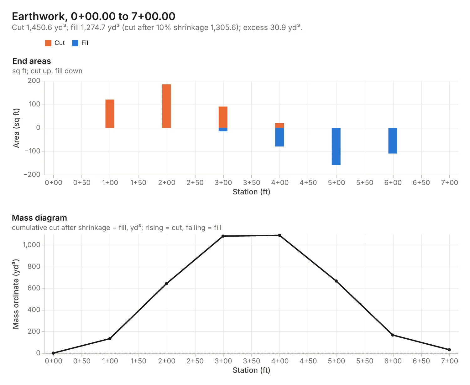
- Cut and fill between cross-sections: volumes by average end areas (with the pyramid rule where cut or fill runs out to zero), shrinkage applied to the cut, the mass diagram ordinates, its highest and lowest points, the balance points (where cut and fill even out) and whether the job ends in waste or borrow.
- Grid (borrow-pit) volumes: cut and fill from corner depths, or from existing elevations and a proposed grade; with no proposed grade, the level grade that balances cut and fill.
- Pits, trenches and stockpiles: excavation volumes with side slopes (prismoidal formula), trench volumes, and conical or ridged stockpiles from their size or angle of repose.
- Hauling: loose volume after swell and the number of truck loads.
- A chart: end areas with the mass diagram, the grid colored by cut and fill depth, or the shape's section drawn to scale.
US units (feet, cubic yards) or metric (metres, cubic metres); results come back in the units you wrote.
It's made for:
- Civil engineers and estimators doing cut and fill take-offs for roads, pads and site grading.
- Contractors pricing excavation, hauling and trucks.
- Civil engineering and surveying students working earthwork and mass-haul problems.
- AI agents that need correct earthwork quantities instead of a guess.
How to use it
- Write Cross-sections, grids and shapes, one per entry. The form has examples.
- Optionally set the Units for requests written without one.
- Click Start. Each request is a row in the results, with its summary, chart and report.
What you can write
| You write | It means |
|---|---|
0+00 cut 0 fill 0; 1+00 cut 120 fill 0; ... sq ft | Cross-sections: station, cut end area, fill end area |
shrinkage 10% | Cut shrinks by 10% when placed as fill (a negative value is swell) |
grid 20 ft squares, cut depths: 2.1 1.8 1.5; 1.9 1.4 1.0 | Corner depths row by row (positive cut, negative fill) |
grid 10 m squares, existing elevations: ...; proposed grade 100.5 | Elevations and a level grade (without one you get the balanced grade) |
pit 20 x 30 m bottom, 3 m deep, side slopes 1.5:1 | An excavation with sloped sides (vertical sides for none) |
trench 100 ft long, 3 ft wide, 6 ft deep, side slopes 1:1 | A trench with vertical ends |
conical stockpile 40 ft diameter, 12 ft high | A cone (any two of diameter, height, angle of repose) |
stockpile 60 x 20 m base, angle of repose 35 | A ridged pile (add a height for a flat top) |
swell 25%, trucks of 10 m3 | Loose volume and truck loads |
The same as objects: {"type": "sections", "sections": [{"station": "0+000", "cut": 45, "fill": 0}, {"station": "0+020", "cut": 30, "fill": 5}], "shrinkage": "15%", "units": "m"} or {"type": "grid", "existing": [[10, 10.4], [9.8, 10.1]], "proposed": 9.5, "spacing": 5, "units": "m"}.
Examples
- The cross-sections above → cut 1,450.6 yd³, fill 1,274.7 yd³; cut after 10% shrinkage 1,305.6 yd³; 30.9 yd³ of excess cut to waste.
borrow pit grid 20 ft squares, cut depths: 2.1 1.8 1.5 1.2; 1.9 1.4 1.0 0.6; 1.2 0.8 0.5 -0.3 ft→ cut 103.8 yd³, fill 0.1 yd³.grid 10 m squares, existing elevations: 102.4 101.9 101.2; 101.8 101.0 100.6; 101.1 100.4 99.8→ balanced grade 101.119 m, 85.7 m³ of cut and of fill.pit 20 x 30 m bottom, 3 m deep, side slopes 1.5:1, swell 25%, trucks of 10 m3→ 2,556.0 m³ bank, 3,195.0 m³ loose, 320 truck loads.conical stockpile 40 ft diameter, 12 ft high→ 186.2 yd³, faces at 31.0°.
How-to examples
Each example is a complete input; the results are from runs of the Actor (also listed under Examples).
How to calculate cut and fill from cross-section end areas
Result: cut 1,450.6 yd³ and fill 1,274.7 yd³; cut after 10% shrinkage is 1,305.6 yd³, leaving 30.9 yd³ of excess cut to waste. The chart has the mass diagram.
How to find the balanced grade of a site from a grid of elevations
Result: balanced grade 101.119 m, with 85.7 m³ of cut and of fill. With cut depths instead, borrow pit grid 20 ft squares, cut depths: ... gives the borrow volume.
How to calculate the volume of a pit and the truck loads
Result: 2,556.0 m³ bank, 3,195.0 m³ loose and 320 truck loads. conical stockpile 40 ft diameter, 12 ft high gives 186.2 yd³ with faces at 31.0°.
How to let an AI agent do earthwork take-offs
Add this Actor to the Apify MCP server with https://mcp.apify.com/?tools=jumblemog/earthwork-calculator. The agent pastes the stations, grid or shape as one line and answers with the cut, fill, waste and truck loads.
FAQ
Which method does it use for cross-sections? Average end areas between stations, and the pyramid rule where one end area is zero; the prismoidal correction isn't applied.
Does it compute end areas from ground points? No. It works from the cut and fill area at each station.
Can a grid have missing points? Yes. Mark blanks with - or x; squares missing a corner are left out, so irregular sites work.
Which shapes can it measure? Pits, trenches and stockpiles with side slopes, by the prismoidal formula, which is exact for plane slopes, and cones.
Input
| Field | What it is |
|---|---|
requests | The cross-sections, grids and shapes, as lines of text or objects (up to 200 per run) |
units | For requests without a unit: m (metres) or ft (feet) |
charts | Draw a chart for each request (default on) |
Output
One dataset item per request, also saved together in the run's OUTPUT record:
Grids add grid (squares, area, balanced grade) and depths; shapes add shape (dimensions, top size, volume); haul appears when you give a swell or truck size. Every item has units, summary, warnings, notes (the method and assumptions), a Markdown report and links to the chart and report. A request that can't be computed has "status": "failed" and the reason in error, and isn't billed.
How it works
- Cross-sections: V = L·(A1 + A2)/2 between stations; where one end area is zero the material tapers out, so V = L·A/3 (the pyramid rule). Volumes in cubic yards (27 cu ft) for feet.
- Mass diagram: running total of cut after shrinkage minus fill; balance points where it crosses zero, linear between sections.
- Grid: each square is A·(sum of its four corner depths)/4; a square with both cut and fill splits as A·(Σcut)²/(4·Σ|h|) and A·(Σfill)²/(4·Σ|h|).
- Balanced grade: corner elevations weighted by how many squares share them (1, 2, 3 or 4).
- Shapes: the prismoidal formula h/6·(A_bottom + 4·A_mid + A_top), exact for plane side slopes; cones πr²h/3.
- Hauling: loose volume = bank volume × (1 + swell); truck loads rounded up.
Pricing
You pay one low price per request, at the prices shown on this page; pits, trenches and stockpiles cost less than cross-sections and grids. The chart and report are included. Requests that can't be computed are never charged. If you set a maximum cost per run, the Actor stops before a request that wouldn't fit.
Speed
Each request takes a few milliseconds. A run through the API answers in about 10 seconds, including the cloud container starting.
Tips and limits
- End areas: this Actor works from the cut and fill area at each station; it doesn't compute areas from ground and template cross-section points.
- Average end areas overstate a little where sections change shape fast; the prismoidal correction isn't applied.
- Grids: depths are existing minus proposed (positive cut). Squares missing a corner are left out, so irregular sites work with blanks (
-orx). - Shrinkage and swell vary by soil; the defaults are none for shrinkage and 25% for swell when you ask for truck loads.
- Limits: 200 requests per run.
For AI agents and developers
This Actor works with the Apify MCP server, so AI agents can call it as a tool. Pass requests as plain text and read summary, totals, sections, grid, shape, haul and warnings. A direct API call that waits for the answer:
run-sync instead returns the run's OUTPUT: the status, the counts and every result as JSON.
In Python, with the apify-client package:
Credits
- Charts: Vega-Lite and vl-convert (BSD-3-Clause), with the Inter font (SIL Open Font License).
- Methods: Wright and Dixon, Highway Engineering; Ghilani and Wolf, Elementary Surveying (earthwork chapter).


