

Road Geometry Calculator: Horizontal & Vertical Curves
Pricing
Pay per event
Road Geometry Calculator: Horizontal & Vertical Curves
AASHTO road curve design from plain text: stopping sight distance, minimum radius and K for a design speed; horizontal curves with PC/PT stations and stakeout; vertical curves with elevations, high or low point and the length for sight distance, with a chart.
Pricing
Pay per event
Rating
0.0
(0)
Developer

Jumble Mog
Maintained by CommunityActor stats
0
Bookmarked
2
Total users
1
Monthly active users
9 days ago
Last modified
Categories
Features
Share
Highway curve design by the AASHTO Green Book, from one line of text. Type design speed 60 mph, horizontal curve R 1000 ft, delta 40°, PI 25+00, 50 mph or crest curve from +2% to -3%, 60 mph, PVI 12+00, elevation 500 ft. You get back:
- Design speed values: stopping sight distance (and on grades from -9% to +9%), side friction, minimum radius for an e max, degree of curve, and the K values for crest and sag vertical curves, matching the Green Book tables.
- Horizontal curves: tangent, curve length, long chord, external, middle ordinate, PC and PT stations, and a stakeout table of deflection angles and chords from the PC at even stations. With a design speed: the minimum radius, the superelevation needed and the sight-line offset for stopping sight distance.
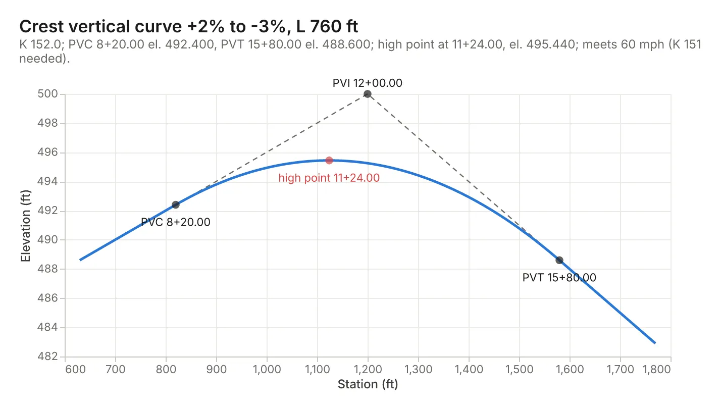
- Vertical curves: PVC and PVT stations and elevations, elevations along the curve (tangent, offset, curve), the high or low point, K and the rate of change. With a design speed: the length needed for stopping sight distance (or the shortest curve, rounded up, when you leave the length out), the sight distance it provides and the comfort length for sags.
- A chart: sight distance and minimum radius against speed, the curve in plan with its PC, PI and PT, or the vertical profile with the tangents and the high or low point.
US customary (mph, ft, 12+34.56 stations) or metric (km/h, m, 1+234.567 stations), as the Green Book does; results come back in the units you wrote.
It's made for:
- Civil engineers and highway designers checking alignments.
- Surveyors staking out curves in the field.
- Civil engineering students working Green Book and FE/PE exam problems.
- AI agents that need correct curve geometry instead of a guess.
How to use it
- Write Design speeds and curves, one per entry. The form has examples.
- Optionally set the Units for requests written without one.
- Click Start. Each request is a row in the results, with its summary, chart and report.
What you can write
| You write | It means |
|---|---|
60 mph, 100 km/h | The design speed |
e max 6% | Maximum superelevation (8% by default) |
downgrade 5%, grade +4% | Grade for the stopping sight distance |
reaction time 2 s | Brake reaction time (2.5 s by default) |
R 1000 ft, radius 300 m, 4° curve | Radius, or degree of curve (arc definition) |
delta 40°, deflection 35°20'15" | Deflection (central) angle |
PI 25+00, PI 1+234.567 | PI station |
every 25 ft, interval 20 m | Stakeout or elevation interval (50 ft or 20 m by default) |
from +2% to -3%, g1 -4%, g2 +1.5% | Grades into and out of a vertical curve |
L 600 ft, K 151 | Vertical curve length, or K |
PVI 12+00, elevation 500 ft | PVI station and elevation |
The same as an object: {"type": "horizontal", "degree": 4, "delta": "25d30'", "pi": "40+00", "speed": "55 mph"} or {"type": "vertical", "g1": 2, "g2": -3, "speed": "60 mph", "pvi": "12+00", "elevation": "500 ft"}.
Examples
design speed 60 mph→ stopping sight distance 570 ft; minimum radius 1200 ft at e max 8%; K 151 crest, 136 sag.100 km/h, e max 6%→ 185 m; minimum radius 437 m; K 52 crest, 45 sag.horizontal curve R 1000 ft, delta 40°, PI 25+00, 50 mph→ T 363.97, L 698.13, LC 684.04, E 64.18, M 60.31 ft; PC 21+36.03, PT 28+34.16; radius OK (758 ft needed).crest curve from +2% to -3%, 60 mph, PVI 12+00, elevation 500 ft→ L 760 ft; PVC 8+20.00 el. 492.400, PVT 15+80.00 el. 488.600; high point at 11+24.00, el. 495.440.sag vertical curve g1 -4%, g2 +1.5%, L 200 m, PVI 2+500, elev 120 m, 90 km/h→ low point at 2+545.455, el. 121.091; too short for 90 km/h (K 38 needed).
How-to examples
Each example is a complete input; the results are from runs of the Actor (also listed under Examples).
How to find the stopping sight distance and minimum radius for a design speed
Result: stopping sight distance 570 ft; minimum radius 1200 ft at e max 8%; K 151 for crest and 136 for sag curves. In metric, 100 km/h, e max 6% gives 185 m, 437 m and K 52 / 45.
How to calculate a horizontal curve's elements and stations
Result: T 363.97, L 698.13, LC 684.04, E 64.18 and M 60.31 ft; PC 21+36.03 and PT 28+34.16; the radius is OK (758 ft needed).
How to design a crest vertical curve
Result: L 760 ft; PVC 8+20.00 at el. 492.400 and PVT 15+80.00 at el. 488.600; the high point is at 11+24.00, el. 495.440.
How to let an AI agent do highway curve design
Add this Actor to the Apify MCP server with https://mcp.apify.com/?tools=jumblemog/road-geometry-calculator. The agent passes the speed or the curve in one line and answers with the Green Book values, curve elements and stations.
FAQ
Which standard does it follow? AASHTO's A Policy on Geometric Design of Highways and Streets (the Green Book, 2018). State DOT manuals, TAC, DMRB and Austroads can differ.
Does it check sag curves? Yes: sag vertical curve g1 -4%, g2 +1.5%, L 200 m, PVI 2+500, elev 120 m, 90 km/h gives the low point at 2+545.455 and says the curve is too short (K 38 needed).
Does it give stake-out data? Yes: stations and deflection angles from the PC for horizontal curves, and elevations along vertical curves.
What isn't covered? Spirals, compound and reverse curves, superelevation runoff and widening. Give each simple curve on its own.
Input
| Field | What it is |
|---|---|
requests | The design speeds and curves, as lines of text or objects (up to 200 per run) |
units | For requests without a unit: m (metric) or ft (US) |
charts | Draw a chart for each request (default on) |
Output
One dataset item per request, also saved together in the run's OUTPUT record:
Design speeds have design and grades; vertical curves have curve, stations, elevations and, with a speed, check. Every item has units, summary, warnings, notes (the method and assumptions), a Markdown report and links to the chart and report. A request that can't be computed has "status": "failed" and the reason in error, and isn't billed.
How it works
All from AASHTO A Policy on Geometric Design of Highways and Streets (the Green Book, 2018):
- Stopping sight distance: 1.47·V·t + 1.075·V²/a (US) or 0.278·V·t + 0.039·V²/a (metric), t = 2.5 s and a = 11.2 ft/s² (3.4 m/s²), rounded up to 5; on grades V²/(30(a/32.2 ± G)).
- Minimum radius: V²/(15(e + f)) or V²/(127(e + f)) with the side friction factors of Table 3-7.
- Horizontal curves: T = R·tan(Δ/2), L = π·R·Δ/180, LC = 2R·sin(Δ/2), E = R(sec(Δ/2) − 1), M = R(1 − cos(Δ/2)); deflections from the PC are arc/(2R); the sight-line offset is R(1 − cos(S/2R)).
- Vertical curves: the equal-tangent parabola y = y_PVC + g1·x + (A/2L)·x², with the high or low point at x = −g1·L/A. Crest lengths for stopping sight distance use a 3.5 ft eye and 2.0 ft object (1.08 m and 0.60 m); sag lengths use headlight sight distance; K = L/|A|, rounded as in the Green Book tables.
Pricing
You pay one low price per request, at the prices shown on this page; design-speed values cost less than curves. The chart and report are included. Requests that can't be computed are never charged. If you set a maximum cost per run, the Actor stops before a request that wouldn't fit.
Speed
Each request takes a few milliseconds. A run through the API answers in about 10 seconds, including the cloud container starting.
Tips and limits
- Spirals (transition curves), compound and reverse curves, superelevation runoff and widening aren't covered; give each simple curve on its own.
- Sight-line offset assumes the sight distance fits within the curve; when it's longer, the tangents matter and the note says so.
- Degree of curve uses the arc definition (100 ft of arc); railways use the chord definition.
- Local standards (state DOT manuals, TAC, DMRB, Austroads) can differ from the Green Book; check the values your agency requires.
- Limits: design speeds 15 to 80 mph or 20 to 130 km/h; 200 requests per run; tables up to 400 rows.
For AI agents and developers
This Actor works with the Apify MCP server, so AI agents can call it as a tool. Pass requests as plain text and read summary, design, curve, stations, check and warnings. A direct API call that waits for the answer:
run-sync instead returns the run's OUTPUT: the status, the counts and every result as JSON.
In Python, with the apify-client package:
Credits
- Charts: Vega-Lite and vl-convert (BSD-3-Clause), with the Inter font (SIL Open Font License).
- Methods: AASHTO, A Policy on Geometric Design of Highways and Streets, 7th edition (2018), chapter 3.


