

UK Road Collision Records — DfT STATS19
Pricing
from $33.50 / 1,000 collision records
UK Road Collision Records — DfT STATS19
Keyless, pay-per-record UK DfT STATS19 collision data. One row per collision — date, location, road, junction, conditions, severity, vehicle/casualty counts. Collision table ONLY; casualty/vehicle person tables never fetched; OGL v3.0; no person data.
Pricing
from $33.50 / 1,000 collision records
Rating
0.0
(0)
Developer
NexGen Signal
Maintained by CommunityActor stats
0
Bookmarked
2
Total users
1
Monthly active users
12 days ago
Last modified
Categories
Share
Keyless. Pay per record. Every reported road collision in Great Britain — collision facts only, no person data.
This actor turns the UK Department for Transport STATS19 road-safety data into clean, per-collision records — the official record of road collisions reported by police across Great Britain. Each run reads the DfT's keyless collision table for the year you choose and delivers one row per collision: when and where it happened, the road and junction, the conditions, the severity, and the collision-level counts of vehicles and casualties. Collision grain, structured for engineering use, under the Open Government Licence, with a hard privacy design: the casualty and vehicle person-attribute tables — sex, age, journey purpose, any person data — are never fetched, joined, or emitted.
What this is, in one paragraph
Police in Great Britain record every road collision involving personal injury under the STATS19 system, and the DfT publishes the result as three linked tables: collisions, casualties, and vehicles. The casualty and vehicle tables carry person-level attributes (the sex and age of drivers and casualties, journey purpose, and more). This actor reads only the collision table — the collision-level facts — and flattens each collision into a single analysis-ready record: date, time, and location, the police force, the road classes and junction detail, the speed limit, the light, weather, and road-surface conditions, the severity, and the collision-level counts of vehicles and casualties involved. The person tables are never touched. Values are exactly as reported. You are billed only for records actually delivered.
Who buys this and for what job
- Road-safety analysts, local authorities, and transport planners mapping collisions by location, road type, severity, and conditions.
- Insurance, telematics, and risk-modelling teams enriching routes and areas with historical collision frequency and severity.
- Researchers and journalists studying road-safety trends by year, force, road type, and condition.
- Data engineers who want the STATS19 collision table as clean rows — with the person tables provably excluded — without downloading and reshaping the yearly CSVs.
Open Government Licence — free commercial reuse
One licence rider travels on every record. DfT STATS19 data is published under the Open Government Licence v3.0 (OGL v3.0) — free to copy, publish, distribute, and adapt, including commercially, with the required attribution: "Contains public sector information licensed under the Open Government Licence v3.0." One honest caveat rides every record too: these are collisions as reported by police forces, not a legal determination of fault, and the collision-level counts are totals, not person records.
Hard privacy design — collision table only, never the person tables
This is the defining property of this actor. The STATS19 casualty and vehicle tables carry person attributes — the sex and age of drivers and casualties, journey purpose, casualty class, home-area type. This actor never fetches, joins, or emits any of them. There is deliberately no code path to the casualty or vehicle files anywhere in the actor — the collision file is the only data door it knows. What it emits is strictly collision-level: geography, road, junction, conditions, severity, and the two collision-level counts (number_of_vehicles, number_of_casualties), which are totals, not people. A person-attribute guard runs on every record as a structural backstop, and the acceptance suite feeds a record deliberately polluted with driver and casualty sex, age, journey purpose, and a person name, and asserts that not one of those attributes — key or value — can ever appear in output. This mirrors the fleet's standing privacy posture: person-attributable content is a hard exclusion, not a narrowing exercise.
Product grain — no person data
The unit of every record is a collision, never a person. Casualty and vehicle counts are carried verbatim as collision-level totals; no person, no name, no age, no sex, no journey purpose is read or emitted.
Sample output
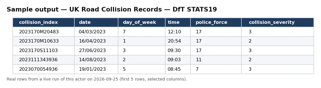
Real rows from a live run of this actor (first 5 rows, selected columns).
One full record from the same run, exactly as delivered:
Pricing
| Event | Free plan | Bronze | Silver | Gold / Platinum / Diamond |
|---|---|---|---|---|
collision_record | $0.05 | $0.045 | $0.04 | $0.0335 |
Delivered before charged. Blocked runs and empty results cost nothing.
Input
| Field | Type | Default | Description |
|---|---|---|---|
reportingYear | integer | 2023 | STATS19 collision reporting year. |
policeForce | string | — | Optional. Keep only collisions for this police-force code. |
severity | string | — | Optional. Keep only collisions of this severity code (1 fatal, 2 serious, 3 slight). |
maxRecords | integer | 10 | Ceiling on records delivered and billed. |
Default changed on 30 Sep 2026: if you leave maxRecords out, a run now returns up to 10 records (it was 500). Set maxRecords yourself to get more — the maximum is unchanged.
Output
One JSON object per collision. Real example (values as reported):
An unbilled RUN_RECEIPT records the robots check, the year and filters, rows seen and delivered, and whether charged equals delivered — plus a notice that only the collision table is read.
Field reference
Each record is one collision. Identity: record_id / collision_index and collision_year. When: date, day_of_week, and time. Where: longitude, latitude, location_easting_osgr, location_northing_osgr, local_authority_district, local_authority_ons_district, local_authority_highway, and lsoa_of_accident_location. Road and junction: first_road_class, first_road_number, road_type, speed_limit, junction_detail, junction_control, second_road_class, and second_road_number. Crossings and conditions: pedestrian_crossing_human_control, pedestrian_crossing_physical_facilities, light_conditions, weather_conditions, road_surface_conditions, special_conditions_at_site, and carriageway_hazards. Context: police_force, collision_severity, urban_or_rural_area, did_police_officer_attend_scene_of_accident, and trunk_road_flag. Counts (collision-level totals): number_of_vehicles and number_of_casualties. Provenance: source, source_url, licence, attribution, disclaimer, and observed_at.
Note: pedestrian_crossing_* are site facility codes (what crossing control exists at the location), not person attributes; number_of_casualties is a count, not a person record.
How a run works
A run first re-reads the source host's robots posture from your runtime — the DfT data host — and stops at the door if a Disallow ever covers the collision path. It then streams the collision CSV for your chosen year — the only file the actor knows how to reach — and flattens each collision to one record, reading a strict collision-only whitelist of fields and carrying the vehicle and casualty counts verbatim, delivered before it is charged, so a blocked or empty run costs you nothing. Your optional policeForce and severity filters are applied before delivery, and the actor stops at your maxRecords ceiling and records charge_equals_delivered in the receipt.
Coverage and scope
A single reporting year holds on the order of 100,000+ reported collisions across Great Britain. Because each record carries collision_year and collision_index, year-over-year work is a simple join, and the geography, road, and condition fields support mapping and hotspot analysis. Pull one year to analyse, several years to build a trend, or filter by policeForce or severity to isolate a region or the fatal/serious subset.
Cost guidance
One collision_record per delivered collision: cost = collisions delivered × your plan's per-record price. Scope with severity or policeForce, and cap with maxRecords. A whole year is ~100,000 collisions; 1,000 collisions is $50 (Free) / $33.50 (Gold).
Honest limitations
- Collision table only. By design, this actor reads only the collision table; the casualty and vehicle person-attribute tables are never fetched, joined, or emitted.
- Counts, not people.
number_of_vehiclesandnumber_of_casualtiesare collision-level totals, not person records. - As reported. Values are coded exactly as police forces report them (STATS19 codes); this actor reformats, it does not decode or interpret fault.
- No person data of any kind.
Differentiation
It is distinct from any vehicle-recall, emissions, or transport-freight cell, and — critically — from the person-level STATS19 casualty and vehicle tables, which this actor deliberately excludes. Its specific job is the DfT STATS19 collision table — collision facts and counts, with the person tables provably out of scope.
The NexGen Signal family
Part of the NexGen Signal family of pay-per-record data products:
- UK Company Status Records — Companies House
- UK Tariff Commodity Records — HS Codes & Taxonomy
- UK Gender Pay Gap Records — Employer Reports
- UK Contract Opportunity Records
- EU Regulatory Change Records — CELLAR
Source: UK Department for Transport, STATS19 road safety data (data.dft.gov.uk). Contains public sector information licensed under the Open Government Licence v3.0 — free to reuse, including commercially, with attribution. Collision table only; the casualty and vehicle person-attribute tables (sex, age, journey purpose, any person data) are never fetched, joined, or emitted. Casualty and vehicle counts are collision-level totals, not person records. Collisions as reported by police, not a determination of fault.


