
French Natural & Industrial Risks – Address Report (Géorisques)
Pricing
from $20.00 / 1,000 address risk reports
French Natural & Industrial Risks – Address Report (Géorisques)
Official risk report for any French address or GPS point from Géorisques: flood, groundwater, coastal, earthquake zone, clay shrink-swell, radon, forest fire, industrial and Seveso sites, polluted soils, natural-disaster decrees and a 0–100 risk score. Batch thousands of addresses.
Pricing
from $20.00 / 1,000 address risk reports
Rating
5.0
(38)
Developer

yck
Maintained by CommunityActor stats
0
Bookmarked
7
Total users
0
Monthly active users
2 days ago
Last modified
Categories
Features
Share
What does French Natural & Industrial Risks do? It produces the official risk picture of any French address or GPS point from Géorisques, the government's risk platform (Ministry of Ecological Transition and BRGM), in one clean row — for one property or thousands.
- 18 hazards with their official status at the address (or in the commune when the address level is unknown): flood, groundwater rise, coastal flooding, earthquake, ground movement, coastline retreat, clay shrink-swell, avalanche, forest fire, volcano, cyclone, radon, classified industrial sites, nuclear, hazardous pipelines, soil pollution, dam failure, mining.
- Key indicators: seismic zone (1–5), clay shrink-swell exposure, radon class (1–3), flood-risk territory (TRI), number of natural-disaster decrees (CatNat) and the latest one.
- Neighbourhood: classified industrial installations and Seveso sites within your radius (nearest first, with distance), former industrial sites and polluted sites, recorded landslides and underground cavities.
- A 0–100 risk score and level (
very-low→high) to sort and compare a portfolio, plus the link to the official Géorisques report. - Batch-ready: addresses, GPS points or a dataset of listings; addresses that can't be located are returned with a clear status and not charged.
Useful for real-estate agents and buyers, notaries and property managers, insurers and lenders, ESG and climate-risk analysts, and anyone screening sites before an investment.
What data can you get?
| 📊 Risk score and level | 🌊 Flood and groundwater | 🌋 Earthquake zone |
| 🧱 Clay shrink-swell | ☢️ Radon class | 🔥 Forest fire |
| 🏭 Industrial and Seveso sites | 🧪 Polluted soils | ⛰️ Ground movements |
| 📜 Disaster decrees | 🗺️ Flood-risk territory | 🔗 Official report |
How to use it
- Click Try for free and open the Actor.
- Paste addresses or GPS points.
- Set the radius for industrial sites and polluted soils.
- Click Start and sort by risk score.
- Export the reports or link a dataset of listings.
Input examples
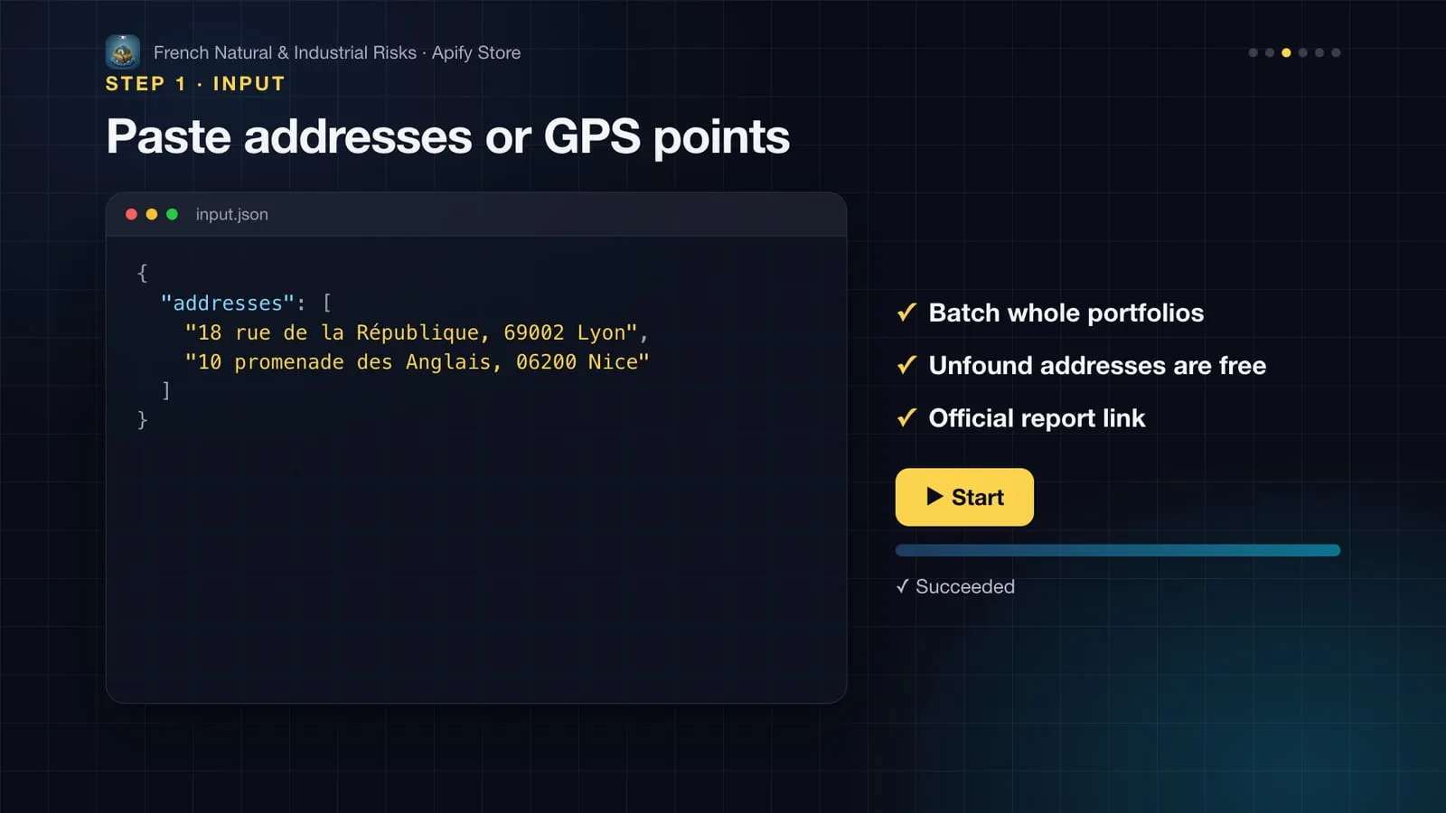
Two addresses
A portfolio of GPS points with your own references and full details
Screen the listings scraped by another Actor
Output
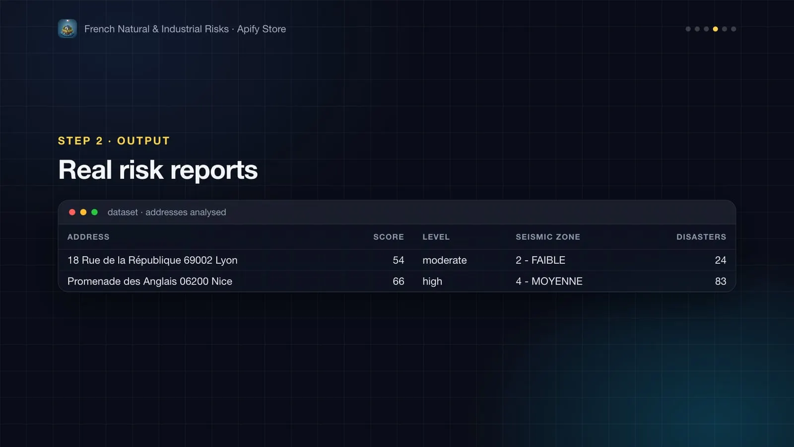
Real reports from the first example (November 2026):
| Address | Score | Level | Seismic zone | Disaster decrees (10 y) | Flood-risk territory |
|---|---|---|---|---|---|
| 18 Rue de la République, 69002 Lyon | 54 | moderate | 2 – low | 24 (1) | Lyon |
| Promenade des Anglais, 06200 Nice | 66 | high | 4 – medium | 83 (16) | Nice Cannes Mandelieu |
| Field | Meaning |
|---|---|
hazards.*.basis | address when Géorisques knows the status at the exact point, commune when only the commune-level status is known. |
hazards.*.level | high, moderate, low, very-low, present (exists, no level given), unknown or none. |
riskScore | 0–100: weighted sum of the hazards present (commune-level ones count 70%), plus recent disaster decrees and nearby Seveso sites. A comparison aid, not an insurance rating. |
radonClass | 1 (low) to 3 (significant) radon potential of the commune. |
formerIndustrialSitesNearby | Former industrial or service sites (CASIAS inventory) within pollutionRadiusM: a hint to check soil quality, not proof of pollution. |
How much does it cost?
$20 per 1,000 address reports ($0.02 per address or point). Each report combines about ten official Géorisques queries. Addresses not found are free.
More Actors from this developer
| 🏠 French Property Sale Prices (DVF) Every French property sale, €/m² and valuations | 🗺️ French Cadastre Parcels Parcel area, PLU zoning, constraints and past sales | 📈 French Rental Yield Rental yield of every French commune |
| 🏫 French Schools French schools with IPS and exam value added | ⚡ French Energy Ratings (DPE) French DPE energy ratings by address or area | 🏗️ French Building Permits French building permits with developer and SIREN |
FAQ
Is this the legal ERP (État des risques) for a sale or rental?
No. The ERP must be filled in and signed for each transaction. This Actor gives the same underlying official information in a structured form, for screening, due diligence and portfolio analysis.
How precise is the geocoding?
Addresses go through the national address base (BAN). Each row shows the address found, geocodingScore and geocodingPrecision (housenumber, street, locality…). Vague addresses are rejected rather than placed somewhere wrong; use GPS points for full control.
Does it cover overseas France?
Yes, wherever Géorisques has data (Guadeloupe, Martinique, Guyane, La Réunion, Mayotte), including cyclone and volcanic hazards.
Can I use it through the API, Make, Zapier or Google Sheets?
Yes. Every run can be started and read through the Apify API (JavaScript and Python clients, CLI, MCP), and Apify integrations connect it to Make, Zapier, n8n, Google Sheets, Slack, webhooks and more.
Something isn't working, or you need another field?
Open an issue on the Issues tab: feedback is read and answered.


