
French Cadastre Parcels – Area, PLU Zoning & Past Sales
Pricing
from $5.00 / 1,000 parcels
French Cadastre Parcels – Area, PLU Zoning & Past Sales
Find French cadastral parcels by address, GPS point, parcel ID or commune section: exact area, PLU/PLUi zone (U, AU, A, N) with its description, planning constraints such as maximum height, pre-emption right or flood areas, and every recorded sale (DVF). Land prospecting at scale.
Pricing
from $5.00 / 1,000 parcels
Rating
5.0
(38)
Developer

yck
Maintained by CommunityActor stats
0
Bookmarked
7
Total users
0
Monthly active users
2 days ago
Last modified
Categories
Features
Share
What does French Cadastre Parcels do? It turns an address, a GPS point, a parcel ID or a whole cadastral section into a complete land sheet: the parcel's exact area, its zoning in the local urban plan (PLU, PLUi or carte communale) with the zone's description, the planning constraints that apply (maximum height, social-mix sectors, protected areas, flood areas, pre-emption right…), and every sale recorded on it since 2021.
- Find parcels four ways: by address (the parcel under or nearest to it), by GPS point, by 14-character parcel ID, or by listing a whole section with area filters — ideal for land prospecting.
- Zoning: zone code (
UCe1b,AUa,N…), type (Urban, Future urban, Agricultural, Natural), full description, plan type and name, approval date and regulation file name. - Constraints from the national urban-planning portal: prescriptions (e.g.
Hauteur Max-25,Secteur de mixité sociale,Espace boisé classé) and information areas (pre-emption right, noise exposure, sanitation, archaeology, UNESCO perimeter…). - Past sales on the parcel from DVF: date, price, property type, living and land area.
- Maps: Géoportail cadastre link, Google Maps link and optional GeoJSON outline for your GIS.
For property developers and land scouts, architects and surveyors, real-estate agents, notaries, solar and EV-charging site finders, and anyone checking what can be built where.
What data can you get?
| 🆔 Parcel ID | 📏 Area | 🗺️ Zone code and type |
| 📝 Zone description | 📘 Plan name and date | 🚧 Prescriptions |
| ℹ️ Information areas | 💶 Past sales | 📍 GPS point |
| 🧭 Géoportail link | 🔷 GeoJSON outline | 🔍 Section search |
How to use it
- Click Try for free and open the Actor.
- Enter addresses, parcel IDs or a commune section.
- Set area filters for land searches.
- Click Start and open the parcels view.
- Export, or add outlines for your GIS.
Input examples
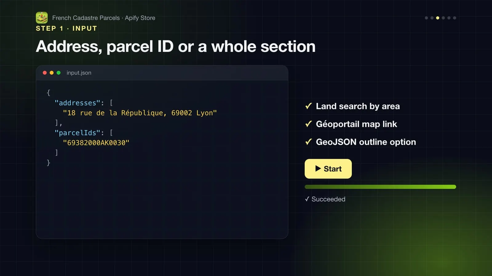
One address and one parcel ID
Land search: every plot over 5 ha in section 0D of Affoux, largest first
GPS points of candidate sites, with outlines for a map
Output
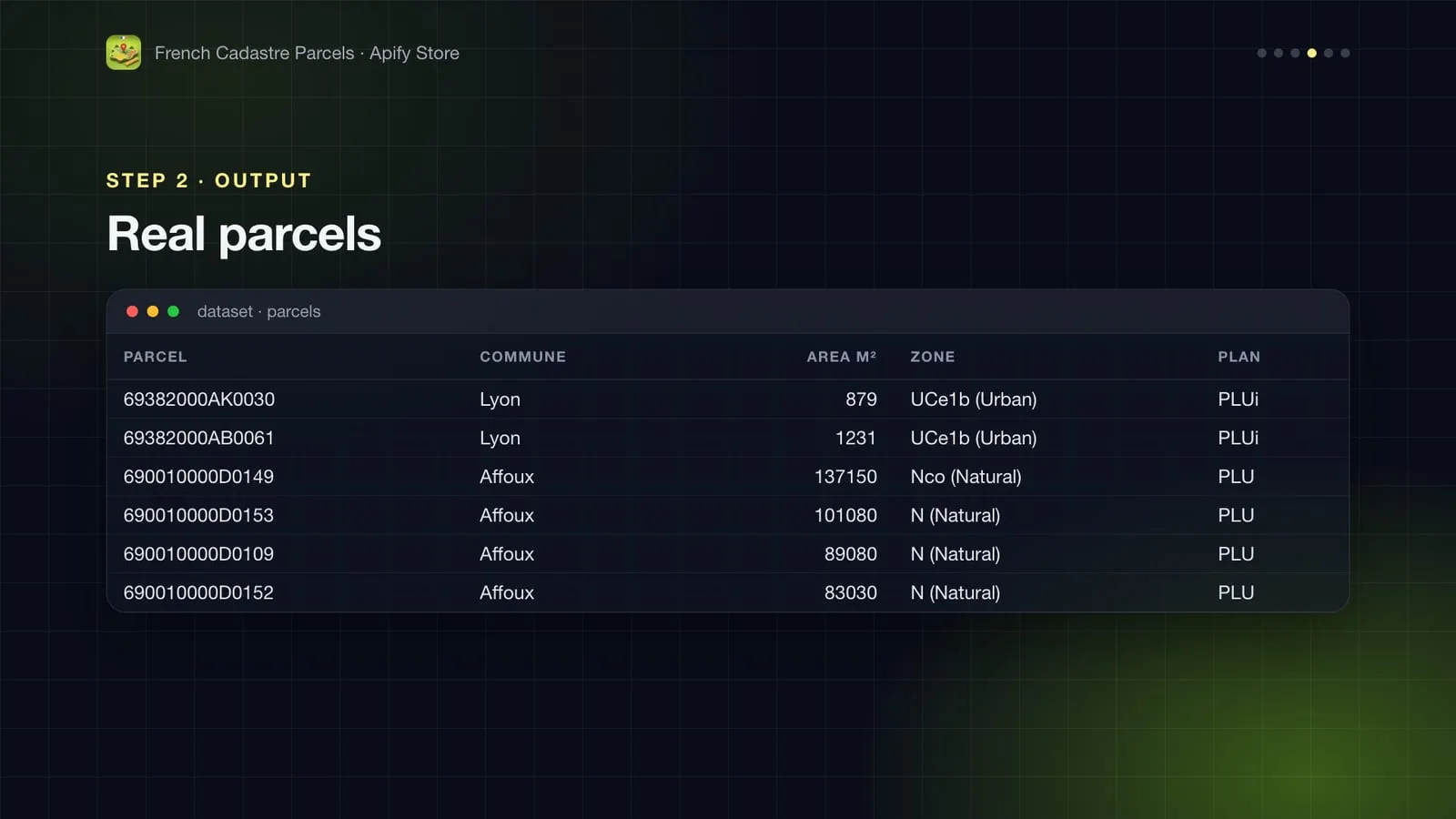
Real parcel from the first example (November 2026):
The land search of the second example returned plots of 13.7 ha, 10.1 ha, 8.9 ha and 8.3 ha in natural zones (N, Nco) of the Affoux PLU; one 7.2 ha plot shows a recorded sale of €16,550.
| Field | Meaning |
|---|---|
parcelId | 14-character cadastral ID: commune (5) + prefix (3) + section (2) + number (4). Paris, Lyon and Marseille use arrondissement codes. |
areaM2 | Official cadastral area (contenance). |
zoneType | U urban, AUc/AUs future urban (open / closed), A agricultural, N natural; ZC / ZnC in communes with a carte communale. |
planningStatus | covered, or no-local-plan (RNU: national rules apply) where the commune has no published plan. |
prescriptions | Planning rules drawn on the parcel: heights, protected trees and woods, social-mix or minimum-size sectors, setbacks, risks… |
sales | Up to 10 sales on the parcel (DVF, since July 2021), newest first. |
How much does it cost?
$5 per 1,000 parcels ($0.005 per parcel returned with its zoning and sales). Inputs that match no parcel are free.
More Actors from this developer
| 🏗️ French Building Permits French building permits with developer and SIREN | 🏠 French Property Sale Prices (DVF) Every French property sale, €/m² and valuations | 🌊 French Natural & Industrial Risks Flood, clay, seismic and industrial risks per address |
| 📈 French Rental Yield Rental yield of every French commune | ⚡ French Energy Ratings (DPE) French DPE energy ratings by address or area | 🏫 French Schools French schools with IPS and exam value added |
FAQ
Where does the data come from?
Parcels: the official cadastre (DGFiP Parcellaire Express via IGN's API Carto). Zoning and constraints: the Géoportail de l'urbanisme, where communes publish their plans. Sales: DVF from the tax administration. All are official open data.
Is the zoning legally binding?
The Géoportail de l'urbanisme is the reference publication of local plans, but a plan may have been amended since. Always check the regulation file and ask the town hall for a certificat d'urbanisme before a transaction.
Why does an address return the neighbouring parcel?
Address points are often placed on the street. When no parcel is under the point, the nearest parcel within about 20 m is returned; check the map link for corner plots.
Can I find the owner?
No. Owner names of parcels owned by private individuals are not open data in France.
Can I use it through the API, Make, Zapier or Google Sheets?
Yes. Every run can be started and read through the Apify API (JavaScript and Python clients, CLI, MCP), and Apify integrations connect it to Make, Zapier, n8n, Google Sheets, Slack, webhooks and more.
Something isn't working, or you need another field?
Open an issue on the Issues tab: feedback is read and answered.


