

EU Grassland Condition Records — Grassland Watch
Pricing
from $33.50 / 1,000 observation records
EU Grassland Condition Records — Grassland Watch
Keyless, pay-per-record EU Grassland Watch data. One row per site/month/variable observation — site code, unit, year, month, variable, value, units. Partition required (country, MONSTER per country); CC BY 4.0; no person data.
Pricing
from $33.50 / 1,000 observation records
Rating
0.0
(0)
Developer
NexGen Signal
Maintained by CommunityActor stats
0
Bookmarked
2
Total users
1
Monthly active users
15 days ago
Last modified
Categories
Share
Keyless. Pay per record. Europe's satellite-monitored grassland condition, site by site, month by month.
This actor turns the European Commission EU Grassland Watch into clean, per-observation records — the satellite-derived monitoring of grassland condition across the EU's Natura 2000 network. Each run reads the Commission's keyless data-query API for the country you choose and delivers one row per site / month / variable observation: the site code, the land-cover unit, the year and month, the measured variable and its value, and the units. Site / unit / month / variable observation grain, structured for engineering use, under the Creative Commons Attribution 4.0 licence, with no personal data of any kind.
What this is, in one paragraph
EU Grassland Watch monitors the condition of protected grasslands using satellite data, and the European Commission publishes the observations. This actor reads that dataset and flattens each observation into a single analysis-ready record: the site code (a protected-area identifier), the land-cover unit id, the year and month of observation, the monitored variable, the observed value, and the units. Values are carried verbatim — the measurement is exactly as published, including zero values. It is the grassland-condition monitoring layer of Europe's protected-area network. You are billed only for records actually delivered.
Who buys this and for what job
- Environmental-monitoring, conservation, and land-use teams tracking grassland condition across protected sites over time.
- Agri-environment and CAP-compliance products studying grassland-condition indicators by site and season.
- Remote-sensing and ESG-analytics teams joining grassland observations to protected-area and habitat datasets.
- Data engineers who want the Grassland Watch observations as clean rows without paging a per-country API by hand.
Creative Commons Attribution 4.0 — free commercial reuse
One licence rider travels on every record. European Commission EU Grassland Watch data is available for reuse under the Creative Commons Attribution 4.0 International (CC BY 4.0) licence per the Commission's legal notice — free to reuse, including commercially, with attribution to the European Commission. That attribution travels on every record. One honest caveat rides too: these are satellite-derived monitoring observations, not a compliance or land-management determination.
Observation grain — no person data
The unit of every record is a site / month / variable observation — a measurement, never a person. The dataset carries no natural-person fields, and this actor emits none, with a person-key guard as a pure backstop. Site codes, unit ids, variables, values, and units are the entire payload.
A required partition — this is a multi-million-row dataset per country
EU Grassland Watch is published as one observation table per country, and each is a MONSTER — Germany alone is over 3.7 million rows. This actor therefore requires a partition: every run must set a countryCode (one of the 27 EU Grassland Watch countries). The country selects its own table; there is no unbounded all-EU pull — it is structurally impossible in code. Optional variable and year filters narrow further, and maxRecords is the hard ceiling.
Sample output
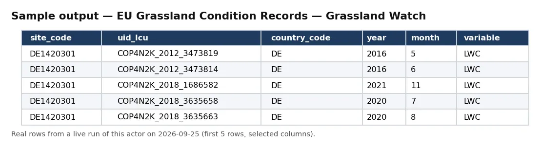
Real rows from a live run of this actor (first 5 rows, selected columns).
One full record from the same run, exactly as delivered:
Pricing
| Event | Free plan | Bronze | Silver | Gold / Platinum / Diamond |
|---|---|---|---|---|
observation_record | $0.05 | $0.045 | $0.04 | $0.0335 |
Delivered before charged. Blocked runs and empty results cost nothing.
Input
| Field | Type | Default | Description |
|---|---|---|---|
countryCode | string | — | Required 2-letter country code (one of the 27 EU Grassland Watch countries, e.g. DE, FR, ES). |
variable | string | — | Optional. Keep only observations of this variable code (e.g. LWC). |
year | integer | — | Optional observation year to filter (e.g. 2016). |
maxRecords | integer | 10 | Ceiling on records delivered and billed. |
Default changed on 30 Sep 2026: if you leave maxRecords out, a run now returns up to 10 records (it was 500). Set maxRecords yourself to get more — the maximum is unchanged.
Output
One JSON object per observation. Real example (values as published):
An unbilled RUN_RECEIPT records the robots check, the country, variable, and year, rows seen and delivered, and whether charged equals delivered.
Field reference
Each record is one observation. Identity: record_id (site + unit + year + month + variable), object_id, site_code, uid_lcu, and country_code. Time: year and month. Measurement: variable, value, and units. Provenance: source, source_url, licence, attribution, disclaimer, and observed_at.
How a run works
A run first re-reads the source host's robots posture from your runtime — the Commission's environmental data-query host — and stops at the door if a Disallow ever covers it. It then pages your country's Grassland Watch observation table, applies your optional variable and year filters, and flattens each observation to one record — carrying the value verbatim, never anything person-shaped — delivered before it is charged, so a blocked or empty run costs you nothing. The actor stops at your maxRecords ceiling and records charge_equals_delivered in the receipt.
Coverage and scope
The dataset spans 27 EU countries, each a separate multi-million-row observation table (Germany alone exceeds 3.7 million rows). A partition is required because of that scale: one country selects its table, and a variable or year narrows to a manageable slice. Because each record carries the site_code, year, month, and variable, a site's condition time series reconstructs by a simple sorted filter.
Working with the observations
The observations are a time series waiting to be assembled, and the identifiers make that mechanical. Every record carries the site_code, uid_lcu, year, month, and variable, so a single filtered pull sorted by year and month reconstructs a site's condition trajectory for a given variable without any cross-table work. The variable field is the lever for comparing indicators — pull one variable across a country to map its spatial pattern, or several variables for one site to profile its condition — and the units travel on every row so a downstream consumer never has to guess a scale. Because the data is published per country and the country is the required partition, a run is always bounded to one national table; combine that with a variable and year and even a MONSTER country becomes a targeted, affordable slice rather than an accidental multi-million-row pull.
Cost guidance
One observation_record per delivered observation: cost = rows delivered × your plan's per-record price. Always scope with countryCode and narrow with variable, year, and maxRecords. 1,000 observations is $50 (Free) / $33.50 (Gold). These are very large per-country tables, so filter and cap deliberately.
Honest limitations
- Monitoring data, not a verdict. These are satellite-derived observations, not a compliance or land-management determination.
- Partition required. Every run must set a
countryCode; there is no unbounded all-EU pull. - As published. Values and units are carried verbatim; this actor reformats, it does not recompute.
- Acknowledge the Commission. The attribution travels on every record.
- No person data of any kind.
Differentiation
It is distinct from the fleet's protected-site register (Natura 2000 designations, not condition observations) and from any emissions or water cell. Its specific job is the EU Grassland Watch observation series — satellite-monitored grassland condition, site by site, month by month.
The NexGen Signal family
Part of the NexGen Signal family of pay-per-record data products:
- EU Natura 2000 Site Records — EEA Protected Sites
- EU Waterbody Quality Records — EEA WISE Waterbase
- EU Industrial Emissions Records — EEA IED Facilities
- EU Bathing Water Quality Records — EEA BWD
- EU Nitrate Monitoring Records — EEA WISE Nitrates
Source: European Commission, EU Grassland Watch (apps.data.env.service.ec.europa.eu). Reused under the Creative Commons Attribution 4.0 International (CC BY 4.0) licence per the Commission's legal notice — free to reuse, including commercially, with attribution to the European Commission. Satellite-derived monitoring observations, not a compliance determination; values carried verbatim. Observation grain; no person data of any kind.


