

FAA Airport Data — US Airport Database from FAA NASR
Pricing
from $33.50 / 1,000 facility records
FAA Airport Data — US Airport Database from FAA NASR
FAA airport data as clean records: a US airport database from the FAA NASR register. Look up airports and heliports by FAA ID (JFK), ICAO (KJFK) or name: location, elevation, ownership, fuel, tower, frequencies. Not for navigation. Part of NexGen Signal — official-source data products
Pricing
from $33.50 / 1,000 facility records
Rating
0.0
(0)
Developer
NexGen Signal
Maintained by CommunityActor stats
0
Bookmarked
2
Total users
1
Monthly active users
10 days ago
Last modified
Categories
Share
FAA airport data, as a US airport database you can query. Every public and private US landing facility from the FAA's NASR register — one clean record per airport, heliport or seaplane base, by FAA location ID, ICAO code, name, state or type.
Keyless. Pay per record. Every US landing facility, cycle by cycle.
This actor turns the US FAA's National Airspace System Resources (NASR) 28-day subscription into clean, per-facility records — the authoritative register of every public and private landing facility in the United States. Each run reads the FAA's keyless bulk subscription file and delivers one row per landing facility: its identifiers, location and elevation, ownership and use, runway-supporting attributes, services, and the frequencies and lighting that describe it. Facility grain, structured for engineering use, in the public domain — and owner and manager personal contact details are structurally excluded and never emitted.
What this is, in one paragraph
NASR is the FAA's master reference for the national airspace: airports, heliports, seaplane bases, gliderports, balloonports, and ultralight fields, published on a 28-day cycle. This actor reads the base landing-facility record for the cycle you choose, filters to the state and facility type you want, and flattens each facility into a single analysis-ready record: identity (site number, location ID, ICAO), geography (state, county, city, coordinates, elevation), classification (facility type, ownership, use), and operational reference data (ARTCC, fuel, repair services, tower, UNICOM/CTAF frequencies, lighting, beacon). Values are exactly as published by the FAA for that cycle. You are billed only for records actually delivered.
Who buys this and for what job
- Aviation software and app builders who need a clean, current airport/heliport reference table keyed by location ID and ICAO, without parsing the FAA's fixed-width subscription format.
- Logistics, drone, and mobility operators mapping landing facilities, ownership type, and services near routes and sites.
- GIS, mapping, and analytics teams placing facilities by coordinates and elevation and enriching them with ARTCC, chart, and frequency data.
- Change-tracking and monitoring products comparing cycle-over-cycle to detect new, deactivated, or reclassified facilities (each record carries its cycle effective date).
Buyers usually search for this as "FAA airport data" or "US airport database".
Public-domain data — with a not-for-navigation caveat
Two honesty riders travel on every record. First, licensing: FAA NASR data is a work of the US federal government — no copyright, public domain under 17 U.S.C. §105 — free to reuse with attribution to the FAA. Second, fitness: this is facility reference data from the 28-day subscription and is not for navigation, flight planning, or operational or safety-of-life use — consult official FAA charts, NOTAMs, and the Chart Supplement before any aviation decision. Values are as published for the cycle shown.
Facility grain — no person data
This actor works at facility grain: one record per landing facility. The underlying NASR base record also carries facility owner and manager personal contact fields — names, mailing addresses, and phone numbers, which for private airfields are often those of individuals. This actor never reads or emits any of them. The owner/manager name, address, and phone byte-ranges are excluded structurally at parse time (they are not in the field map at all), a person-key guard runs on every record as a backstop, and the acceptance suite feeds a synthetic record carrying planted owner and manager names and phone numbers and asserts none of it can ever appear in output. What you get is the facility, not the person behind it.
Sample output
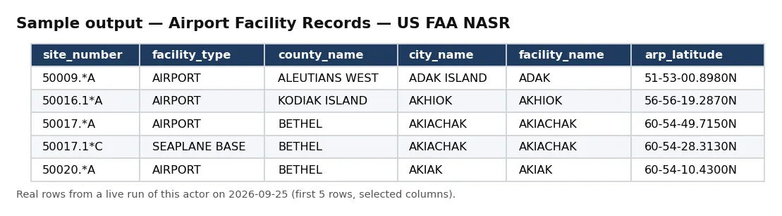
Real rows from a live run of this actor (first 5 rows, selected columns).
One full record from the same run, exactly as delivered:
Pricing
| Event | Free plan | Bronze | Silver | Gold / Platinum / Diamond |
|---|---|---|---|---|
facility_record | $0.05 | $0.045 | $0.04 | $0.0335 |
Delivered before charged. Blocked runs and empty results cost nothing.
Input
| Field | Type | Default | Description |
|---|---|---|---|
faaLocationIds | array | — | Optional. Exact FAA location identifiers (location_id), e.g. JFK, 0AK. |
icaoIds | array | — | Optional. Exact ICAO identifiers as NASR publishes them (icao_id), e.g. KJFK. |
nameContains | array | — | Optional. Text in the facility name, e.g. Kennedy. |
cycle | string | latest | NASR 28-day cycle effective date (YYYY-MM-DD). Blank uses the latest available cycle. |
state | string | — | Optional. Keep only facilities in this US state/territory (full name, e.g. CALIFORNIA, ALASKA). |
facilityType | string | — | Optional. Keep only facilities whose type contains this text (e.g. AIRPORT, HELIPORT, SEAPLANE BASE). |
maxRecords | integer | 10 | Ceiling on records delivered and billed. |
Default changed on 30 Sep 2026: if you leave maxRecords out, a run now returns up to 10 records (it was 500). Set maxRecords yourself to get more — the maximum is unchanged.
Look up a facility: {"faaLocationIds": ["JFK", "LGA", "EWR"], "maxRecords": 10} returns those three airports from the latest cycle. Identifier systems are kept apart: location_id is the FAA location identifier and icao_id the ICAO code (KJFK); this actor does not output IATA codes. Many US airports use the same three letters for their FAA and IATA codes, but not all do, so the actor never treats them as interchangeable. When several lookup fields are set, a facility matching any of them is returned. No match = nothing charged.
Output
One JSON object per landing facility. Real example (values as published by the FAA, Aspen-Pitkin County / Sardy Field, 2026-08-06 cycle):
An unbilled RUN_RECEIPT records the robots check, the cycle and file, the filters, facilities seen and delivered, whether charged equals delivered, and a note that owner/manager person fields are never emitted.
Field reference
Each record is one landing facility. Identity: record_id / site_number, location_id, icao_id, and facility_type. Geography: faa_region, state_code, state_name, county_name, county_state, city_name, arp_latitude, arp_longitude, elevation_ft, magnetic_variation, sectional_chart, dist_from_cbd_nm, dir_from_cbd, and land_area_acres. Classification: ownership_type(_desc) and facility_use(_desc). Airspace and reference: boundary_artcc_id, responsible_artcc_id, activation_date, arff_certification, and npias_code. Services and equipment: fuel_types, airframe_repair, powerplant_repair, lighting_schedule, beacon_schedule, control_tower, unicom_freq, ctaf, segmented_circle, beacon_lens_color, and landing_fee. Provenance and caveats: cycle_effective_date, traffic_pattern_altitude (where published), source, source_url, licence, attribution, disclaimer, and observed_at.
How a run works
A run first re-reads the door host's robots posture from your runtime — the NASR subscription files live under nfdc.faa.gov/webContent/, which that host's robots.txt explicitly allows — and stops at the door if that ever changes. It then resolves the current 28-day cycle (or the cycle you name) by probing the FAA's cycle grid for the live APT.zip, downloads it, and streams the fixed-width file, keeping only the base landing-facility records (one per facility). Each facility is parsed by field position — reading only the facility fields and never the owner/manager contact byte-ranges — and delivered before it is charged, so a blocked or empty run costs you nothing. Your optional state and facilityType filters bound the pull, and the actor stops at your maxRecords ceiling and records charge_equals_delivered in the receipt.
Facility types and coverage
A NASR cycle covers on the order of 19,000+ US landing facilities, and this actor surfaces the facility_type on every row. Types include AIRPORT, HELIPORT, SEAPLANE BASE, GLIDERPORT, BALLOONPORT, and ULTRALIGHT fields, spanning public and private ownership and use. Because each record carries state, county, city, and coordinates, you can scope by geography as well as by type. Pass a single facilityType to build a focused feed — say, only heliports — or a state to pull one state's facilities for a bounded, low-cost run, or take a whole cycle and group downstream. Each record's cycle_effective_date makes cycle-over-cycle change tracking straightforward: pull two cycles and diff by site_number.
Cost guidance
One facility_record per delivered facility: cost = facilities delivered × your plan's per-record price. A full cycle is ~19,000+ facilities, so scope with state and facilityType to keep runs bounded — one state's airports is typically a few hundred to a couple thousand. 1,000 facilities is $50 (Free) / $33.50 (Gold).
Honest limitations
- Not for navigation. Reference data only — not for flight planning, navigation, or any operational/safety-of-life use. Use official FAA charts, NOTAMs, and the Chart Supplement.
- Base facility record. This is the landing-facility base record; runway-by-runway detail, remarks, and attendance schedules are separate NASR record types not emitted here.
- Some legacy fields are no longer populated. Based-aircraft and annual-operations counts that once lived in this file are blank in the current subscription, so they are not emitted (a null-always field is noise, not data).
- As published, per cycle. Values are exactly as the FAA distributes them for the cycle shown; this actor reformats, it does not recompute.
- No person data — owner/manager names, addresses, and phone numbers are structurally excluded.
Differentiation
This actor is the FAA's NASR landing-facility register — the static, cycle-published reference of where the airports, heliports, and other facilities are and what they offer. It is not an aircraft safety-directive feed and not live flight tracking: facility reference records ≠ airworthiness mandates ≠ flight tracks.
The NexGen Signal family
Part of the NexGen Signal family of pay-per-record data products:
- Storm Event Records — US NOAA / NCEI
- Natural Hazard Event Records — NASA EONET
- Air Quality Monitor Records — US EPA AQS
- EPA Facility Compliance Records — Envirofacts
- US Treasury Fiscal Records — Rates & Debt
Source: US FAA National Airspace System Resources (NASR) 28-day subscription. NASR data is a work of the US federal government, no copyright, public domain (17 U.S.C. §105); free to reuse with attribution to the FAA. Reference data only — not for navigation or operational use. Reformatted to facility records; owner/manager person contact fields are structurally excluded and never emitted.


