

MarineTraffic Scraper | Vessel Positions and ETA
Pricing
from $1.26 / 1,000 vessels
MarineTraffic Scraper | Vessel Positions and ETA
MarineTraffic scraper for vessel tracking by IMO, MMSI, name or area: last AIS position with time, speed, course and status, destination and ETA, last and next port, draught, flag, type, deadweight and photo. 10 vessels in 3 seconds, 47 fields each, in 2026. No account needed, one row per vessel.
Pricing
from $1.26 / 1,000 vessels
Rating
0.0
(0)
Developer

SilentFlow
Maintained by CommunityActor stats
0
Bookmarked
2
Total users
1
Monthly active users
3 days ago
Last modified
Categories
Features
Share
MarineTraffic Scraper | Vessel Positions, ETA and Voyages by IMO or MMSI (2026)
From SilentFlow. Creators of Facebook Search Scraper and JD Products Scraper (#1 for “jd” in Apify Store search), with 1,000,000+ combined lifetime runs.
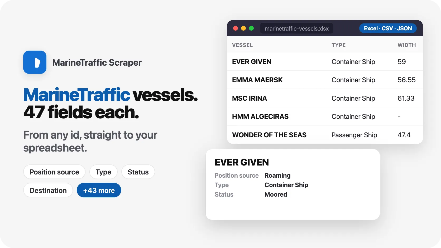
Turn a list of IMO or MMSI numbers into one clean row per vessel: where it is, when that position was received, where it is heading, its declared ETA, the port it left and when, the port it is bound for, its draught, flag, type, size and tonnage. 10 vessels in 3 seconds, 100 vessels in 19 seconds, without a MarineTraffic account.
Why choose this actor?
Still opening vessel pages one by one to update ETAs for your customers? Rebuilding a tonnage list by hand every morning? Waiting on a sales call to get vessel data you can see on a public page?
- Your whole fleet list in one run. Paste IMO numbers, MMSI numbers, MarineTraffic ship IDs, vessel links or exact names, mixed in one list. Each vessel comes back as exactly one row, whatever the list size. In our run, 10 vessels named by IMO and MMSI came back in 3 seconds.
- The full vessel card on every row. Identity, particulars, last AIS position and current voyage share one flat row of 49 fields. In our run every one of the 10 rows had its declared ETA, destination, last port with its departure time, draught, year built and photo; 9 of 10 also named the next port.
- Know how fresh each position is. Every row carries the time its position was received and its age in minutes, so your alerts can tell a vessel reporting now from one out of coastal range. In our run 5 of the 10 positions were under 5 minutes old.

Try your first vessel
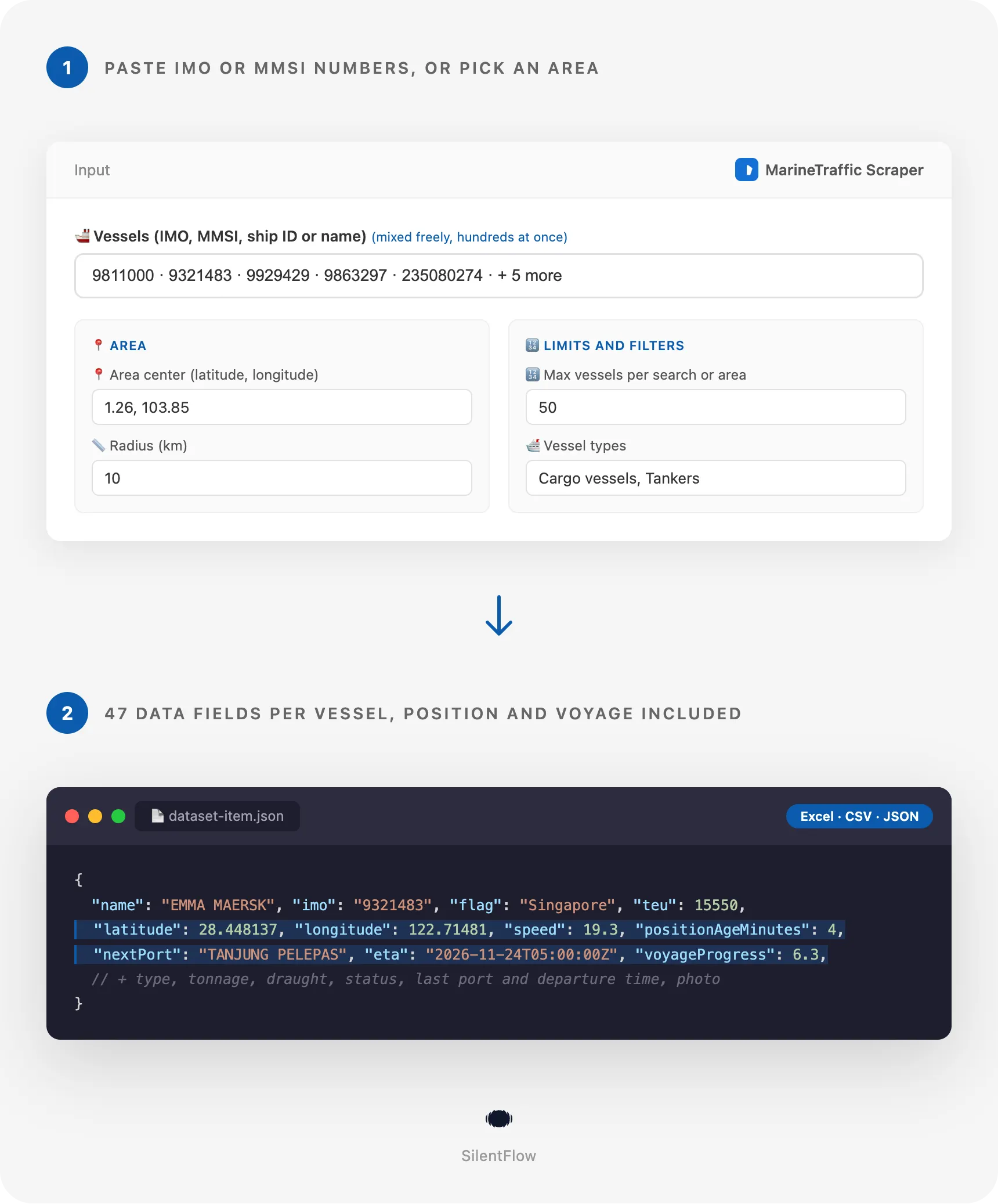
Paste this input into the actor's Input tab (JSON view) and press Start:
You get 10 rows: the container ships EVER GIVEN, EMMA MAERSK, MSC IRINA and HMM ALGECIRAS, the cruise ships WONDER OF THE SEAS and QUEEN MARY 2, the ore carrier ORE BRASIL, the crude tanker FRONT ALTAIR, the LNG tanker AL DAFNA, and the ferry STENA BRITANNICA, looked up by its MMSI. In our run the 10 rows took 3 seconds, each with 42 to 48 of its 49 fields filled. The Apify Free plan is enough to run it: no credit card, no MarineTraffic account, no API key.
Copy to your AI assistant
Paste this block into Claude, ChatGPT or Cursor to give it full context about this scraper:
How to scrape MarineTraffic vessel positions and ETAs
Track a handful of vessels by IMO
The simplest run: a few IMO numbers, one row each.
Mix IMO, MMSI, links and names from your own list
Your booking system may hold an MMSI for one vessel, a link for another and only a name for a third. Paste them as they are.
List cargo ships and tankers around a port approach
Every vessel within 10 km of the Rotterdam approach point, nearest first, keeping only cargo vessels and tankers. In our run 239 vessels were in range before the type filter.
Input parameters
| Parameter | Type | Default | What it does |
|---|---|---|---|
vesselIds | array of strings | 10 example vessels | IMO, MMSI, ship ID, vessel link or exact name, mixed. One row per vessel, never capped by maxItems. |
searchQueries | array of strings | none | Vessel names to search. Every match becomes a row, up to maxItems per search. |
startUrls | array of links | none | MarineTraffic vessel pages, or live map views that list the vessels on screen. |
areaCenter | string | none | "latitude, longitude" in decimal degrees. Lists the vessels around that point, nearest first. |
radiusKm | integer | 10 | Radius around areaCenter, 1 to 1,000 km. |
maxItems | integer | 50 | Most rows per search and per area. |
vesselTypes | array | all types | Keep only cargo, tanker, passenger, fishing, tug, highSpeed, pleasure or other in searches and areas. |
debugMode | boolean | false | Writes a detailed log. |
Accepted formats
- IMO:
9811000,IMO 9811000,imo:9811000. A 7 digit number is read as an IMO when its check digit is valid. - MMSI:
636026627,MMSI 636026627,mmsi:636026627. A 9 digit number is read as an MMSI. - MarineTraffic ship ID:
shipid:5630138, or any other bare number. - Vessel links:
https://www.marinetraffic.com/en/ais/details/ships/shipid:5630138/mmsi:636026627/imo:9811000/vessel:EVER_GIVEN, and the shorter/ships/imo:9811000or/ships/mmsi:636026627forms. - Vessel names in the vessel list:
EVER GIVEN. You get every vessel in service with exactly that name; a scrapped namesake is left out when a vessel in service carries the name. - Map views:
https://www.marinetraffic.com/en/ais/home/centerx:103.85/centery:1.26/zoom:12. The zoom sets the area: near the equator zoom 12 covers about 20 km around the center, and each zoom level out doubles that. - Areas:
1.26, 103.85or51.95;4.05, latitude first.
Entries the actor cannot read (a link to another site, a malformed number) are listed in the log and skipped; the rest of the run goes on.
What data can you extract from MarineTraffic?
Each row is one vessel with 49 fields in five groups:
| Group | Fields |
|---|---|
| Identity (15) | id, url, name, imo, mmsi, callSign, flag, flagCode, vesselType, aisType, market, sizeClass, aisClass, status, homePort |
| Particulars (7) | length, width, deadweight, grossTonnage, teu, liquidGas, yearBuilt |
| Last AIS position (12) | latitude, longitude, speed, course, heading, rateOfTurn, navigationalStatus, draught, positionReceivedAt, positionAgeMinutes, areaName, positionSource |
| Current voyage (12) | destination, eta, lastPort, lastPortCountry, lastPortDepartureAt, nextPort, nextPortCountry, nextPortArrivalAt, hasArrived, voyageProgress, averageSpeed, maxSpeed |
| Media and meta (3) | photoUrl, query, scrapedAt |
Useful facts about the data:
idis MarineTraffic's own ship ID andurlthe permanent vessel page: both stay the same for the life of the vessel, so they are safe keys for a database.imoandmmsiare strings, so a join with your own lists never loses a digit.- Every date is in RFC 3339 UTC (
2026-11-24T05:00:00Z).etais the ETA the crew declared;nextPortArrivalAtis the estimated arrival at the next port, or the actual arrival whenhasArrivedis true. destinationis free text typed by the crew (CNNPO>MYTPP,ROTTERDAM);nextPortis the port name the site matched it to.- Measures are in metres, tonnes, knots and degrees. A measure the site does not know is
null, never0. photoUrllinks the vessel's main photo, 800 pixels wide; it isnullwhen nobody has uploaded one.
Output example
Advanced usage
Refresh a fleet list every morning
Save your list once as a task and schedule it daily in the Apify Console (Schedules). Each run gives the same vessels in the same order, so you can compare eta, destination, navigationalStatus and draught with yesterday's run and alert on what moved.
Build a tonnage list of one fleet by name
A name search returns every vessel whose name matches, here up to 100 MAERSK container ships with their position, status and next port. In our run a 100-vessel name search took 19 seconds.
Snapshot an anchorage from a map view you already use
Copy the address of the live map from your browser and paste it: the actor reads the vessels on that view, nearest to the center first. In our run a Singapore Strait view at zoom 12 held 1,217 vessels.
Check the vessels named on your trade documents
Compliance teams paste the IMO numbers from letters of credit or bills of lading and check that each vessel exists, flies the expected flag, has the expected type and sits where the voyage says. Vessels the site does not know are listed in the log, never as empty rows.
Send the rows to a spreadsheet from Python
Run the actor from your own code and keep only the vessels whose ETA changed since your last export.
The same rows are available as CSV, Excel, JSON or XML from the dataset page, or from https://api.apify.com/v2/datasets/{DATASET_ID}/items?format=csv&token=YOUR_TOKEN.
FAQ
What does this MarineTraffic scraper extract? One row per vessel: identity (name, IMO, MMSI, call sign, flag, type, market and size class), particulars (length, width, deadweight, gross tonnage, TEU, year built), the last AIS position with the time it was received, and the current voyage (declared destination and ETA, last port with departure time, next port with arrival time, progress). 49 fields in all.
What is MarineTraffic? MarineTraffic is the best known public ship tracking website. It collects the AIS signals vessels broadcast and shows, for each vessel, where it is, where it is going and what it is. Its full data is sold by subscription and through a data service on quote; this actor reads the public vessel pages anyone can open.
Do I need a MarineTraffic account or an API key? No. The actor reads the public vessel pages. No login, no API key, nothing to install.
How fresh are the positions?
Each row is read live at run time. positionReceivedAt says when the position was received and positionAgeMinutes how old it was at that moment. Near the coast a position is usually minutes old: in our run 5 of 10 vessels had reported within the last 5 minutes. Far out at sea a vessel may keep its last coastal position for hours or days, and the age tells you so.
How many vessels can one run return?
A list of identifiers has no fixed limit: every vessel you give returns its row. Searches and areas stop at maxItems each (50 by default). A broad name search matches up to 500 vessels; a busy port area holds hundreds.
Can I mix identifiers, searches and areas in one run? Yes. A single input can carry a list of IMO numbers, a few name searches, an area and map links. A vessel found twice (by IMO and by MMSI, or in a search and an area) is saved once.
Why is a field sometimes null?
Because MarineTraffic does not show it for that vessel. Small craft often have no IMO, deadweight or photo; a vessel with no declared voyage has no ETA or next port; TEU only exists for container ships and liquid gas capacity for gas carriers. The actor writes null rather than an empty string or a zero.
Do I get port call history, calculated ETA, owners or satellite positions? No. MarineTraffic keeps the port call history, its own calculated ETA, ownership and satellite positions for subscribers. The actor gives what a visitor sees: the ETA declared by the crew, the last and next ports, and the latest position.
Are the links and photos permanent?
url is the permanent vessel page and id never changes for a vessel. photoUrl points to the current main photo; if the photo is replaced on the site, a new run gives the new link.
Can I filter an area or a search by vessel type?
Yes, with vesselTypes: cargo, tanker, passenger, fishing, tug, highSpeed, pleasure or other. Filters combine: areaCenter "51.95, 4.05" with radiusKm 10 and vesselTypes cargo and tanker returns the merchant vessels of the Rotterdam approach, nearest first. Vessels you name by identifier are always returned, whatever their type.
More SilentFlow scrapers
🛒 E-commerce
- JD - JD Products Scraper | JD.com Prices, Brands and Barcodes
- Pinterest - Pinterest Scraper | Pins, Boards and Profiles
- Udemy Course - Udemy Course Scraper
- TikTok Shop - TikTok Shop Scraper | Products, Sellers and Creator Videos
- Leboncoin - Leboncoin Scraper | Classified Ads, Prices and Sellers
- Back Market - Back Market Scraper | Refurbished Prices
- Leboncoin - Leboncoin Ad Details Scraper
- Allegro - Allegro Scraper | Products, Prices and Sellers
- Naver - Naver Scraper | Shopping Products, Prices and Reviews
- Coupang - Coupang Scraper | Product Details, Prices and Options
- Taobao - Taobao Scraper | Products, Details, Prices and Sellers
- Keepa - Keepa Scraper | Amazon Price History and Offers
- Naver - Naver Reviews Scraper | Shopping Product Reviews
- Amazon Seller - Amazon Seller Scraper | Emails, Phones and Ratings
- ImportYeti - ImportYeti Scraper | Suppliers, Importers and Bills of Lading
- Naver - Naver Products Scraper | Shopping Prices, Sellers and Ratings
- Eventim - Eventim Scraper | Events, Ticket Prices and Venues
- 1688 - 1688 Scraper | Products, Reviews, Details, Wholesale Prices
- Wildberries - Wildberries Scraper | Product Details, Prices and Sellers
- Avito - Avito Scraper | Listings, Prices and Sellers
- Bring a Trailer - Bring a Trailer Scraper
- GasBuddy - GasBuddy Scraper | Gas Prices by Station
- Leboncoin - Leboncoin Scraper
- Pinterest - Pinterest Scraper
- 1688 - 1688 Reviews Scraper | Product Reviews, Ratings, Buyer Photos
- Back Market - Back Market Scraper | Refurbished Electronics Prices
- Ctrip - Ctrip Scraper | Attractions, Tickets and Reviews
- Goofish - Goofish Detail Scraper | Xianyu Details, Prices and Sellers
- Store Leads Ecommerce - Store Leads Ecommerce Scraper
- Vinted Marketplace - Vinted Marketplace Scraper
- Alibaba - Alibaba Scraper | Products, Supplier Companies and Prices
- Avito - Avito Profiles Scraper | Sellers, Ratings and Reviews
- BAUHAUS - BAUHAUS Scraper | Product Prices, EAN and Specs
- CARFAX - CARFAX Scraper | Used Cars, Prices and History
- Che168 - Che168 Scraper | Used Car Listings and Prices
- Europages - Europages Scraper | Suppliers and B2B Companies
- Homedepot - Homedepot Reviews Scraper | Customer Reviews and Ratings
- Judge - Judge Scraper | Reviews, Ratings and Store Profiles
- Leboncoin - Leboncoin Details Scraper | Full Ad Data and Sellers
- Lowes - Lowes Products Scraper | Prices, Stock and Specs
- Sahibinden - Sahibinden Scraper | Real Estate and Car Listings
- VividSeats - VividSeats Scraper | Tickets, Prices and Events
- Acquire - Acquire Scraper | Startups for Sale & Prices
- Agoda - Agoda Scraper | Hotel Prices and Guest Ratings
- Barnes and Noble - Barnes and Noble Scraper | Book Prices and Availability
- Boohoo - Boohoo Scraper | Products, Prices and Stock
- Coles - Coles Products Scraper | Prices, Specials and Nutrition
- eBay Marketplace - eBay Marketplace Scraper
- Edmunds - Edmunds Scraper | Car Listings, Prices and Deal Ratings
- Encar - Encar Scraper | Used Car Listings and Accident History
- GetYourGuide - GetYourGuide Scraper | Tours, Activities, Prices & Reviews
- Google Hotels - Google Hotels Scraper | Prices, Offers and Ratings
- MakersRow - MakersRow Scraper | Manufacturers, Capabilities and Reviews
- Mobile.de - Mobile.de Scraper
- OfferUp - OfferUp Scraper | Listings, Prices and Sellers
- OLX - OLX Scraper | Brazil Listings, Prices and Sellers
- Store Leads - Store Leads Scraper | Shopify Data
- Ticombo - Ticombo Scraper | Ticket Prices and Listings
- Tradeindia - Tradeindia Scraper | Suppliers, Products and Contacts
- Turo - Turo Scraper | Car Rentals, Prices and Reviews
- Udemy - Udemy Scraper
- Walmart - Walmart Scraper | Prices, Reviews, Sellers, Availability
- Webmotors - Webmotors Scraper | Car Listings, Prices and FIPE
- Woolworths - Woolworths Products Scraper | Prices, Specials and Nutrition
- YandexMarket - YandexMarket Scraper | Products, Prices and Sellers
- Zap - Zap Scraper | Prices and Store Offers
- Alibaba - Alibaba Products Scraper | Products, Suppliers, Prices and MOQ
- AliExpress - AliExpress Reviews Scraper | Product Reviews, Ratings, Feedback
- AliExpress - AliExpress Scraper | Products, Prices and Sales
- Amazon - Amazon Product Scraper
- Amazon Marketplace - Amazon Marketplace Scraper
- Apple - Apple Scraper | App Store Apps, Ratings and Charts
- AutoScout24 - AutoScout24 Scraper
- Carousell - Carousell Scraper | Listings, Prices and Sellers
- eBay Listings - eBay Listings Scraper
- Europages Deep Dive Extractor - Europages Deep Dive Extractor | VAT, Decision Makers, ISO Certs
- Fashionphile - Fashionphile Scraper | Listings, Prices and Sold Items
- Mercari - Mercari Scraper | Listings, Sold Prices and Sellers
- RA - RA Scraper | Events, Lineups and Tickets
- TickPick - TickPick Scraper | Ticket Prices and Events
- Trip - Trip Scraper | Hotels, Prices and Reviews
- Uniqlo - Uniqlo Scraper | Products, Prices and Stock
- Vinted - Vinted Scraper
- Walmart - Walmart Product Scraper
💼 Jobs
- ZipRecruiter - ZipRecruiter Jobs Scraper | Salary, Company & Location Filters
- Jobright - Jobright Scraper | Jobs, Salaries and H1B Sponsors
- Malt Freelancer - Malt Freelancer Scraper
- Glassdoor Job Listings - Glassdoor Job Listings Scraper
- Multi Board - Multi Board Job Scraper
- Indeed - Indeed Company Reviews Scraper
- Glassdoor - Glassdoor Jobs Scraper
- Jora - Jora Jobs Scraper
- Welcome to the Jungle - Welcome to the Jungle Scraper | Jobs and Company Data
- Francetravail - Francetravail Scraper | Job Offers and Salaries
- LinkedIn Job Search - LinkedIn Job Search Scraper | Salaries & Seniority
- Arbeitsagentur - Arbeitsagentur Jobs Scraper
- Cutshort - Cutshort Jobs Scraper | Salaries, Skills and Companies
- Dice - Dice Scraper | US Tech Jobs, Salaries and Skills
- Dice Tech - Dice Tech Jobs Scraper
- Freelancermap - Freelancermap Scraper | Projects, Skills and Companies
- 🔥 Glassdoor - 🔥 Glassdoor Scraper
- Gupy - Gupy Jobs Scraper | Brazil Jobs and Employers
- iimjobs - iimjobs Jobs Scraper | MBA, Finance and Hirist Tech Jobs
- Indeed - Indeed Companies Scraper | Reviews, Salaries, Interviews
- Instahyre - Instahyre Jobs Scraper | Companies, Recruiters and Ratings
- Jora - Jora Scraper | Jobs in Australia, New Zealand, Singapore
- Kununu - Kununu Scraper | Employee Reviews, Ratings and Interviews
- Malt - Malt Scraper | Freelance Profiles
- Naukri & NaukriGulf - Naukri & NaukriGulf Jobs Scraper
- Totaljobs - Totaljobs Jobs Scraper | UK Job Listings and Salaries
- Welcome to the Jungle - Welcome to the Jungle Job Scraper
- YCombinator - YCombinator Jobs Scraper | Startup Jobs, Salaries and Founders
- All - All Jobs Scraper
- Arbeitsagentur - Arbeitsagentur Scraper | German and Austrian Job Board
- ATS - ATS Jobs Scraper | Greenhouse, Lever and Ashby
- iimjobs - iimjobs Scraper | Jobs, Companies and Recruiters
- Indeed - Indeed Jobs Scraper | NLP Skills
- Indeed - Indeed Jobs Scraper | Job Listings in 73 Countries
- LinkedIn - LinkedIn Jobs Scraper
- Seek - Seek Job Scraper
- StepStone - StepStone Scraper
- Zhaopin - Zhaopin Scraper | Jobs, Salaries and Companies
- Ziprecruiter - Ziprecruiter Scraper
🏠 Real estate
- SeLoger - SeLoger Scraper | Real Estate Listings
- Realtor Rental Listings - Realtor Rental Listings Scraper
- Airbnb Pro Host Contact & - Airbnb Pro Host Contact & Email Scraper
- Bien'ici - Bien'ici Scraper | Property Listings
- Airbnb Professional Host - Airbnb Professional Host Scraper | Emails, Phones, SIRET
- Trulia Rental Listings - Trulia Rental Listings Scraper
- Realestate.com.au - Realestate.com.au Scraper
- Realtor - Realtor Detail Scraper | Property Details and Price History
- SeLoger - SeLoger Scraper | French Property Listings and Agencies
- Bienici - Bienici Scraper
- Idealista - Idealista Scraper
- Rightmove - Rightmove Scraper
- Airbnb - Airbnb Detail Scraper | Listings, Hosts and Availability
- Cian - Cian Scraper | Real Estate Listings and Phones
- Fincaraiz - Fincaraiz Scraper | Real Estate Listings and Prices
- Imovelweb - Imovelweb Scraper | Real Estate Listings
- Propwire - Propwire Scraper | Property Owner Leads
- Redfin - Redfin Detail Scraper | Property Data, Estimates and Flood Risk
- Redfin - Redfin Scraper | Listings, Sold Homes and Agents
- SeLoger - SeLoger Products Scraper | Property Listings and Agencies
- Zapimoveis - Zapimoveis Scraper | Real Estate Listings and Prices
- Zillow - Zillow Scraper
- Airbnb Search - Airbnb Search Scraper | Prices, Fees, Amenities, Hosts
- Airbnb Search - Airbnb Search Scraper
- Anjuke - Anjuke Scraper | Rental Listings, Prices and Agents
- Domclick - Domclick Scraper | Real Estate Listings
- Idealista - Idealista Scraper
- OpenRent - OpenRent Scraper | Rental Listings and Landlords
- Realtor Rental - Realtor Rental Scraper
- Trulia Rental - Trulia Rental Scraper | US Rentals, Prices, Pet Policy
📣 Social media
- Douyin - Douyin Transcript Scraper | Transcripts, Subtitles and SRT
- Facebook Search - Facebook Search Scraper
- LinkedIn Post Search - LinkedIn Post Search Scraper | Keywords, Hashtags & Profiles
- Instagram - Instagram Story Scraper | Stories & Highlights
- TikTok Creative - TikTok Creative Ads Scraper | Top Ads, Landing Pages & Metrics
- Facebook Search - Facebook Search Profiles Scraper | People by Name or Keyword
- LinkedIn Leads - LinkedIn Leads Scraper | Sales Navigator Export
- TwitchTracker - TwitchTracker Scraper | Twitch Streamer Stats and Rankings
- OnlyFans - OnlyFans Profile Scraper
- Reddit - Reddit Scraper | Posts, Comments and Subreddits
- TikTok Trend - TikTok Trend Scraper | Trending Hashtags and Videos
- Discord - Discord Scraper | Servers, Member Counts and Invites
- LinkedIn Hashtag & - LinkedIn Hashtag & Post Scraper | No Cookies
- Snapchat - Snapchat Videos Scraper | Spotlight Videos, MP4 and Stats
- Discord - Discord Profiles Scraper | Users, Badges and Server Tags
- Likee - Likee Scraper | Videos, Hashtags and Creators
- LinkedIn People Search - LinkedIn People Search Scraper | Profiles & Companies
- LinkedIn Sales Navigator - LinkedIn Sales Navigator Scraper
- Pinterest - Pinterest Ads Scraper | Ad Library, Reach & Targeting
- Reddit - Reddit Comments Scraper | Search, Threads and Replies
- Snapchat - Snapchat Contacts Scraper | Phones, Emails and Websites
- Bilibili - Bilibili Scraper | Videos, Comments, Profiles, Danmaku
- Facebook Business Page - Facebook Business Page Scraper
- Kwai - Kwai Scraper | Videos, Creators and Hashtags
- LinkedIn Ads Library - No Cookies - LinkedIn Ads Library Scraper - No Cookies
- LinkedIn Event - LinkedIn Event Scraper
- Pornhub - Pornhub Videos Scraper | Search, Tags and Stream Links
- Reddit - Reddit Profiles Scraper | User Karma, Activity and Communities
- Skool Community - Skool Community Scraper
- Telegram - Telegram Comments Scraper | Replies, Authors and Reactions
- TikTok Lookalike - TikTok Lookalike Scraper | Influencers, Emails and Engagement
- Twitch - Twitch Contacts Scraper | Emails and Social Links
- X Timeline - X Timeline Scraper | Tweets and Engagement Stats
- Bandsintown - Bandsintown Scraper | Concerts and Tour Dates
- Bluesky - Bluesky Scraper | Posts, Profiles and Followers
- Douyin - Douyin Comments Scraper | Comments, Likes and IP Regions
- Douyin - Douyin Hashtags Scraper | Views, Creators and Topics
- Facebook Thread - Facebook Thread Profiles Scraper | Followers, Bios & Engagement
- Kuaishou - Kuaishou Scraper | Videos, Comments and Creator Stats
- Meta Ad Library - Meta Ad Library Scraper
- Pikabu - Pikabu Scraper | Posts, Comments and Views
- Pinterest - Pinterest Profiles Scraper | Followers, Emails and Bios
- Pinterest Trends - Pinterest Trends Scraper | Trending Keywords and Forecasts
- Pinterest - Pinterest Videos Scraper | Video Downloader, MP4 Links, Stats
- RedNote - RedNote Videos Scraper | Xiaohongshu Videos, Transcripts, Stats
- Snapchat - Snapchat Enricher Scraper | Account Age, Activity and Contacts
- Telegram - Telegram Scraper | Channel Posts, Views and Reactions
- TikTok - TikTok Scraper
- Twitch - Twitch Scraper | Streamers, Emails and Clips
- Xigua - Xigua Scraper | Videos, Creators and Downloads
- YouTube Autocomplete - YouTube Autocomplete Scraper | Keyword Suggestions
- YouTube - YouTube Channel Scraper | Videos, Shorts and Views
- YouTube - YouTube Transcript Scraper
- Facebook - Facebook Company Scraper | Emails, Phones, Ratings
- Instagram Engagement - Instagram Engagement Scraper
- LoyalFans - LoyalFans Scraper | Creator Profiles and Prices
- OnlyFans - OnlyFans Profiles Scraper | Creator Prices, Stats & Links
- OnlyFans - OnlyFans Creator Scraper
- Reddit - Reddit Scraper | Comments, Posts and Users
- RedNote - RedNote Detail Scraper | Xiaohongshu Details, Images, Videos
- Skool Group - Skool Group Scraper
- Snapchat - Snapchat Ads Scraper | Ad Library, Impressions & Targeting
- Telegram - Telegram Posts Scraper | Views, Reactions and Comments
- Weibo - Weibo Scraper | Posts, Profiles, Followers and Engagement
🏢 Business data
- LinkedIn Company Search - LinkedIn Company Search Scraper | Profiles & Firmographics
- Teachable Course - Teachable Course Scraper
- Website Tech Stack - Website Tech Stack Scraper
- Teachable - Courses, Prices & Instructors - Teachable Scraper - Courses, Prices & Instructors
- Trustpilot - Trustpilot Scraper | Reviews, Ratings and Company Contacts
✈️ Travel
- Tencent - Tencent Scraper | Maps Places, Phones and Ratings
- Viator - Viator Reviews Scraper | Tour Reviews and Ratings
- Booking.com Hotel - Booking.com Hotel Scraper
- Despegar - Despegar Reviews Scraper | Hotel Reviews and Ratings
- 2GIS - 2GIS Reviews Scraper | Ratings, Photos and Owner Replies
- Apple Maps - Apple Maps Scraper | Places, Phones and Emails
- Flightpoints - Flightpoints Scraper | Award Flights, Miles and Seats
- Google Maps - Google Maps Scraper
- Kakao - Kakao Scraper | Map Places, Reviews and Phones
- Mafengwo - Mafengwo Scraper | Attractions, Ratings and Tickets
- OpenTable - OpenTable Reviews Scraper | Restaurant Reviews and Ratings
- Resy - Resy Scraper | Restaurants and Open Tables
- TheFork - TheFork Scraper | Restaurants, Menus and Ratings
- Trip - Trip Reviews Scraper | Hotel Reviews and Ratings
- Zomato - Zomato Reviews Scraper | Restaurant Ratings and Replies
- Booking - Booking Scraper | Hotel Prices, Photos, Availability
- Flight Price - Flight Price Scraper
🎯 Lead generation
- Northdata - Northdata Company Scraper
- Dealroom - Dealroom Scraper | Companies and Investors
- ZocDoc - ZocDoc Scraper | Doctors, Reviews and Availability
- KVK - KVK Scraper | Dutch Companies and SBI Codes
- UK Companies House - UK Companies House Enricher
- SIRET - SIRET Company Enricher
- PagesJaunes - PagesJaunes Scraper | French Business Emails and SIRET
- Dealroom Startup Data - Dealroom Startup Data Scraper
- Similarweb - Similarweb Scraper | Website Traffic, Rankings and Competitors
- BuiltWith - BuiltWith Scraper | Tech Stacks and Top Sites
- Clutch - Clutch Scraper | Agencies, Reviews, Ratings, Services
- Justdial - Justdial Companies Scraper | Business Leads, Phones and Emails
- PagesJaunes - PagesJaunes Business Scraper
- ThomasNet Suppliers - ThomasNet Suppliers Scraper
- ZocDoc - ZocDoc Scraper
- ALEO - ALEO Scraper | Polish Companies and Financials
- Allabolag - Allabolag Detail Scraper | Company Data, Financials and Board
- BBB - BBB Scraper | Ratings, Reviews and Complaints
- BetaList - BetaList Scraper | Startups, Websites and Contacts
- Company Data - Company Data Scraper | Emails, Phones and Tech Stack
- CSLB - CSLB Scraper | Contractor Licenses, Bonds and Leads
- Delaware - Delaware Scraper | Corporations, LLCs and Registered Agents
- Etimad - Etimad Scraper | Tenders, Awards and Deadlines
- French Company Prospector - French Company Prospector
- G2 - G2 Reviews Scraper
- Oregon - Oregon Scraper | Contractor Licenses and Complaints
- Paginasamarillas - Paginasamarillas Scraper | Business Leads, Emails and Phones
- Pappers - Pappers Scraper | French Companies, Directors & Financials
- SEC - SEC Scraper | EDGAR Filings and Company Data
- SIRET French - SIRET French Company Enricher
- SoftwareAdvice - SoftwareAdvice Scraper | Reviews, Ratings and Pros & Cons
- Sunbiz - Sunbiz Scraper | Florida Companies and Officers
- TrustRadius - TrustRadius Scraper | Software Reviews, Ratings, Pros and Cons
- USPTO - USPTO Scraper | Trademark Search and Status
- Clutch Agency - Clutch Agency Scraper
- CNPJ Brazilian - CNPJ Brazilian Company Enricher
- Domain - Domain Enricher
- Sunbiz - Sunbiz Companies Scraper | New Florida Business Leads
🔎 SEO
- SpyFu - SpyFu Scraper | SEO, PPC and Competitor Data
- Scribd - Scribd Scraper | Documents, Authors and Views
- Bing - Bing Enricher Scraper | Mobile Friendly Test and Indexing
- Google Ads Transparency - Google Ads Transparency Scraper
- Google News - Google News Scraper
- IPinfo - IPinfo Scraper | IP Geolocation and Abuse Contacts
- Urlscan - Urlscan Scraper | Scan Reports, Verdicts and IPs
- Yandexsearch - Yandexsearch Scraper | Search Results and Rankings
- Apple - Apple Reviews Scraper | App Store Reviews and Ratings
🎬 Video
📰 News
- ForexFactory - ForexFactory Scraper | Economic Calendar and Forecasts
- FT - FT Scraper | Financial Times Articles, Authors and Topics
- OpenAI - OpenAI Scraper | News, Blog Posts and Research
- DEV - DEV Scraper | Articles, Full Text and Authors
- Reuters - Reuters Scraper | News Articles, Tickers and Journalists
- TipRanks - TipRanks Scraper | Analyst Ratings and Price Targets
- Bloomberg - Bloomberg Scraper | News Articles and Full Text
🧰 More tools
- PrizePicks - PrizePicks Scraper | Player Props, Lines and Projections
- FanDuel - FanDuel Scraper | Odds, Spreads and Player Props
- Equibase - Equibase Scraper | Horse Racing Entries and Results
- Screener - Screener Scraper | Stock Fundamentals, NSE & BSE
- Maersk - Maersk Scraper | Vessel Schedules and Port Calls
- Twelvedata - Twelvedata Scraper | Stock Data and Analyst Estimates
- Wunderground - Wunderground Scraper | Weather History and Stations
Support
Need something this scraper doesn't do yet? We ship features fast.
- Feature requests go straight to our backlog
- Enterprise needs? We do custom integrations and high-volume plans
- Pricing questions? Check the Monetization tab on the actor page
Response time: usually under 24 hours.
Legal compliance
This Actor extracts publicly available data from MarineTraffic vessel pages. It does not bypass any login, paywall or CAPTCHA, and it does not read the data MarineTraffic reserves for subscribers. Users are responsible for complying with MarineTraffic's terms of service and with applicable data protection laws (GDPR, CCPA, and PIPL where relevant). The output describes vessels, not people, but call signs and vessel names can relate to individuals for small private craft: handle such rows accordingly. Vessel positions and ETAs are informational; verify them before using them for navigation, safety or regulated decisions.
MarineTraffic Scraper by SilentFlow: positions, ETAs and voyages of any vessel, by IMO, MMSI, name or area, one clean row per vessel.


